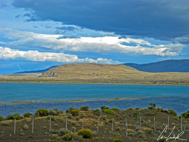
Complete change of scenery… we are in El Calafate, the capital of the province of Santa Cruz and the gateway to majestic glaciers. The town is named for the little indigenous Calafate bush (Berberis buxifolia) with yellow flowers and dark blue berries common in Patagonia, as mentioned in the previous article. Locals say, anyone eating Calafate berries wants more, and this saying is translated into the adage that anyone who visits El Calafate wants to stay forever… El Calafate is located near the Southern border of the Lago Argentino in the heart of the Patagonian Pampas, about 200 miles northwest of Rio Gallegos. El Calafate is a boomtown. The sloping roofs, lenga and guindo woods, and the colorful rosaries give it a unique character. It almost feels like home ! El Calafate is also an important tourist destination as it is the starting point for all tours of the Ice age, including those to Los Glaciares National Park, nestled in the heart of the enchanting mountainous landscape of the Patagonian Andes. Already dreaming of it? It is time to head towards these new fairytale landscapes of Patagonia and to gaze at these frosted beauties…
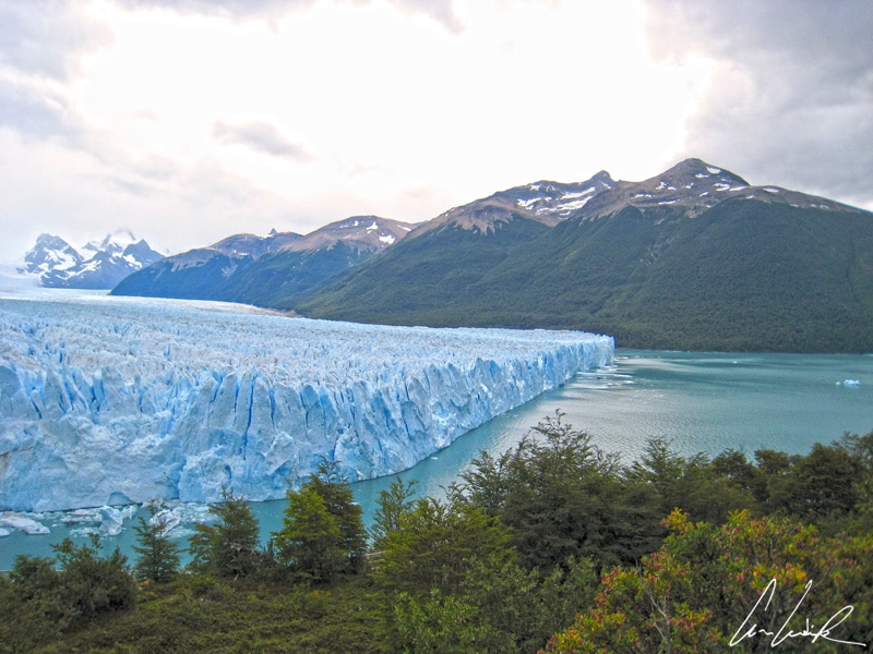
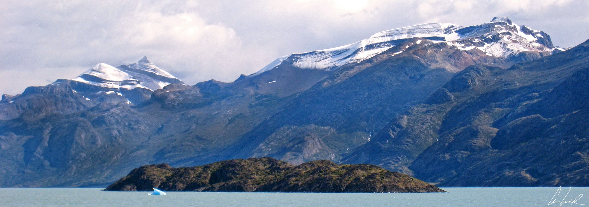
The Los Glaciares National Park was established in 1937. In 1981 the park was declared a UNESCO World Heritage site. It covers an area of 2, 806.68 square miles, making it the largest park in Argentina. Its name is derived from the large ice cap in the Andes that feeds 47 major glaciers, including Marconi, Viedma, Moyano, Upsala, Agassiz, Bolado, Onelli, Peineta, Spegazzini, Mayo, Ameghino, Moreno and Frias. Each of these 13 glaciers flows into the Atlantic. It is part of the Southern Patagonian Ice Field between Chile and Argentina, covering an area 310 miles long and 8,495 square miles in size. It is the third largest ice field in the world after Antarctica (5,400,000 mi2) and Greenland (677,855 mi2)… it makes you feel cold, no ? The park also includes two large elongated lakes with iced and milky waters, Lago Viedma in the North (420 mi2) and Lago Argentino in the South (566 mi2), into which all 13 glaciers flow, including the most famous and largest the Perito Moreno glacier.
Perito Moreno north
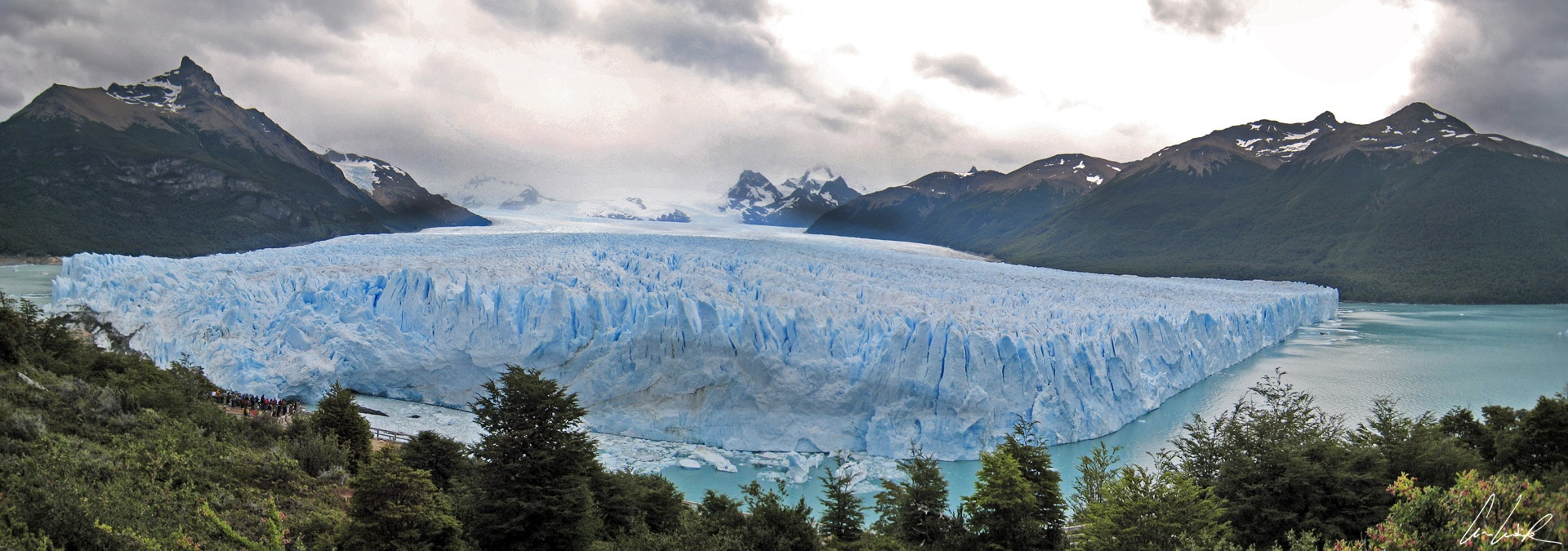
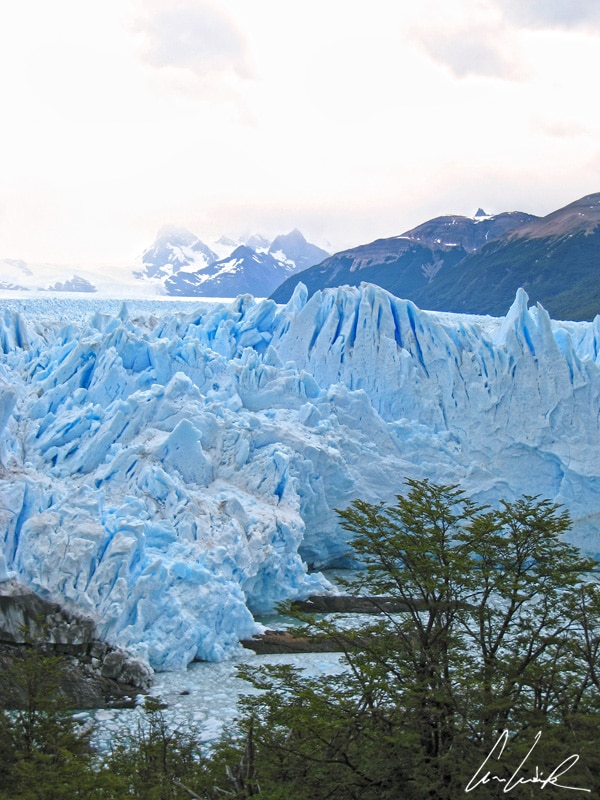
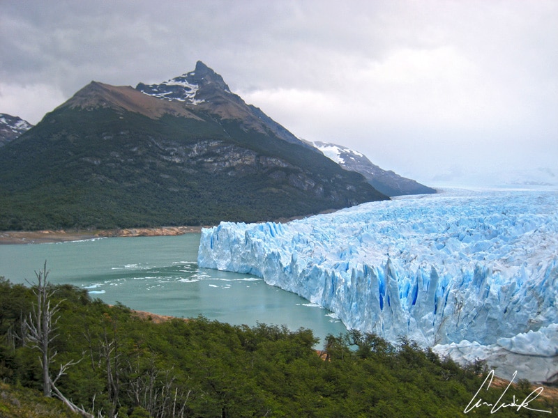
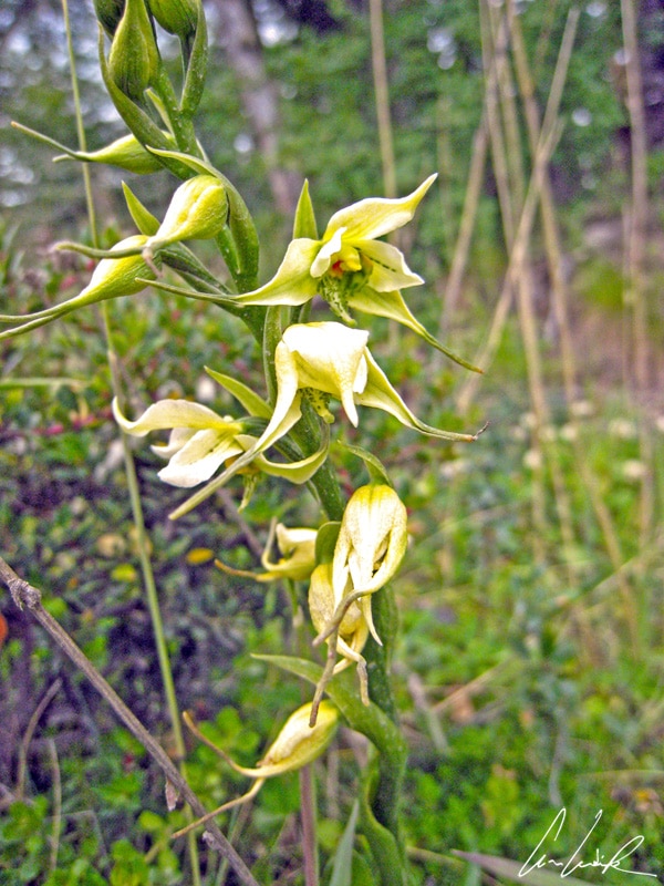
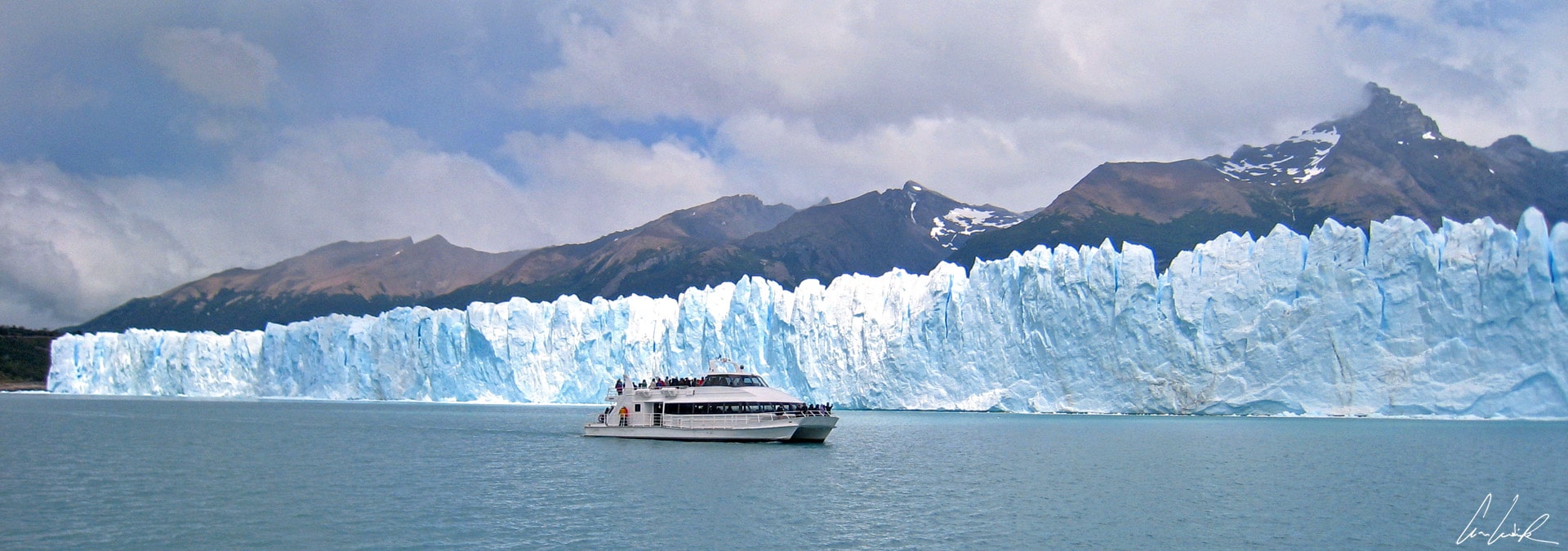
The Perito Moreno Glacier, a gigantic mass of ice in the heart of the Park just next to Lago Argentino, covers an area of 97 square miles and is 19 miles long and 5 miles wide. Perito Moreno Glacier, an icy splendor is towering between 100 and 240 feet above Lago Argentino. By way of comparison, imagine the whole city of Buenos Aires or of Boston covered with ice! We feel minuscule in front of this massive ice field creaking and grinding as it slowly advances… and we fully expect to see Jon Snow pursued by the white walkers in one of the episodes of Games of Thrones! Perito Moreno Glacier was named after the 19th-century pioneer and geographer Francisco Moreno and lies 48 miles from El Calafate. The glacier advances about half a mile per year towards “Brazo Rico”, the southern arm of Argentino Lake, damming and separating the section from the main body of the lake. With no outlet, the water level rises as much as 98 feet above the main part of the lake. Under pressure the water gradually erodes the ice until the ice dam breaks, causing huge ruptures in the glacial tongue. Colossal blue-tinged ice pieces regularly fall into the lake rumbling like thunder and sending a huge mass of water from the Brazo Rico into the main body of Argentino Lake. A rupture is a fascinating natural spectacle and a unique phenomenon that occurs about every four to five years. The last rupture was on March 10th, 2016. Another peculiarity of the glacier is that it is exceptionally rare to see a glacier so close at low altitude and so close to a wooded valley. The undergrowth in the forest contains mostly various species of Nothofagus but also, Cypripedium Acaule also called yellow lady’s slipper, a terrestrial orchid with a very strange flower with modified petals (labella) which fold inward like the toe of a slipper. Also to be found is Gavilea Araucana, another orchid measuring about 2 feet high and recognizable by its beautiful white flowers highlighted by green lines. The area is a habitat for birds and animals, but unfortunately, we meet Scart, Manny, Sid or Diego… another time perhaps?
Boca del Diablo
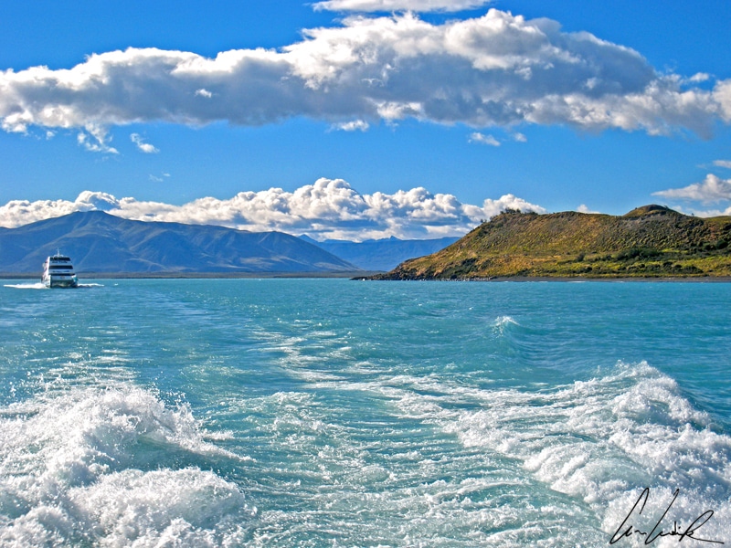
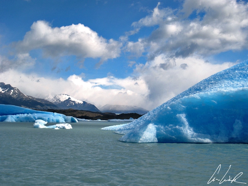
One question remains “in suspenso”… What happens to these icy blue pieces falling into the lake ? To find out there is no need to call Sherlock, just board a boat on Lago Argentino for an excursion amid these giant blue-white icebergs. Lago Argentino, the biggest in Argentina, covers an area of 566 square miles and is 20 miles across at its widest point. The average depth is 492 feet and the maximum depth 1,640 feet. The lake’s water is colored a very particular turquoise blue by sediment -“milky blue” or “frozen milk” according to the Argentines who recall one of their culinary specialties, “dulce de leche.” The boat ride starts at the port of Punta Bandera about 30 miles from El Calafate. The excursion goes through the Boca del Diablo (Devil’s Mouth) into the Northern arm of the lake and the canal Upsala. Boca del Diablo is the narrowest point (half a mile) confined by Mount Castillo. We sail on frigid turquoise water surrounded by striking steep cliffs and subantarctic forests called Magellanic… I would rather say magical.
The boat
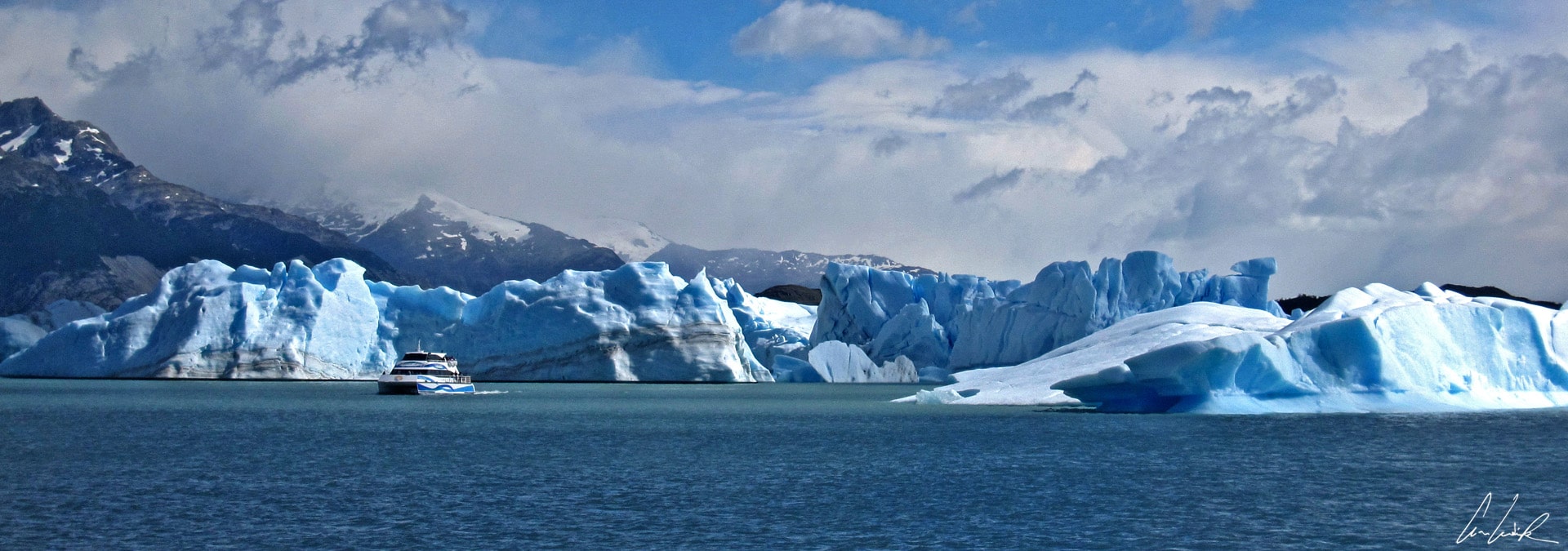
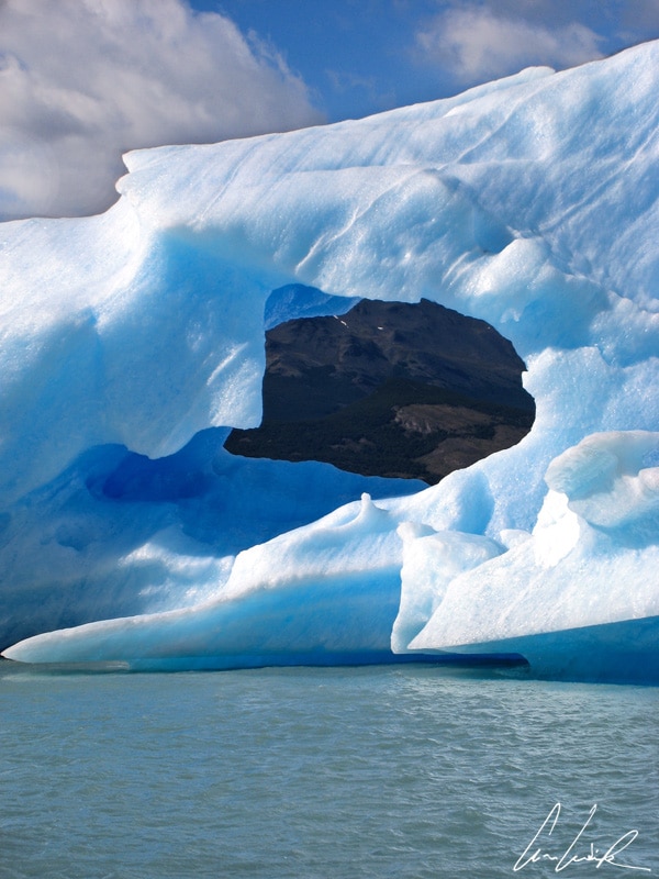
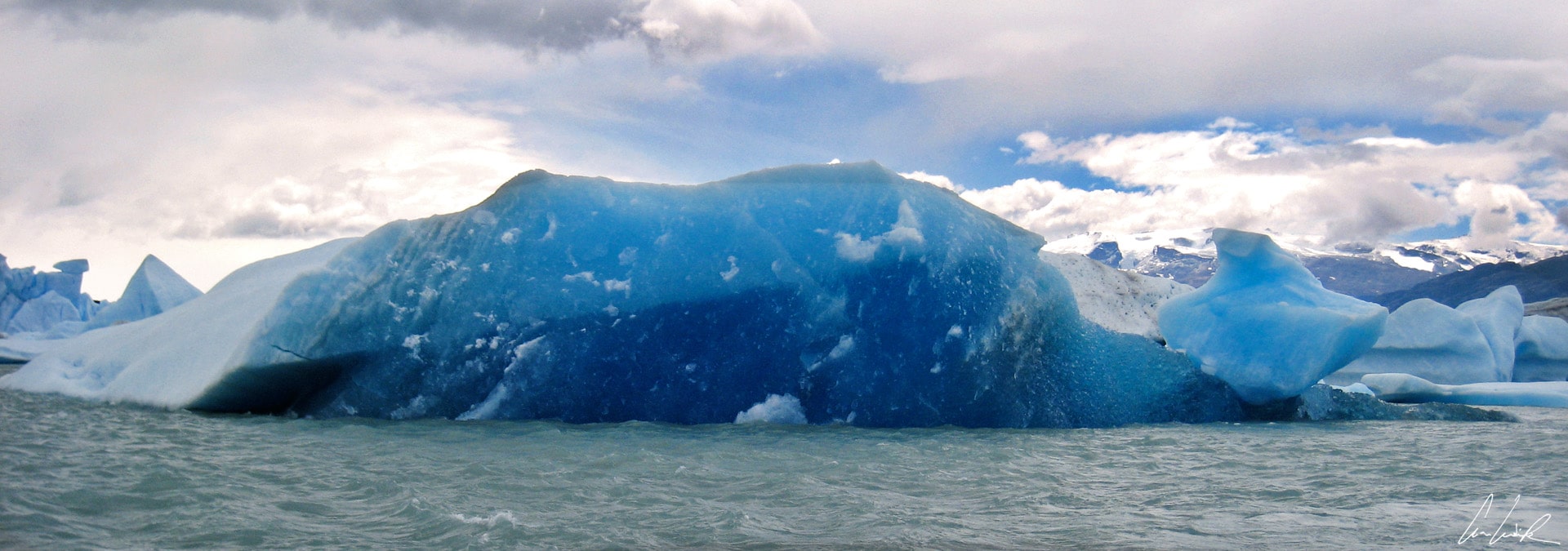
The boat, without fear of becoming Titanic 2, defies the icebergs glistening in the sun and takes us to within a few feet away from the Spegazzini glacier wall – at 450 feet the highest of the glaciers glacial walls. The banks of Canal Upsala are wooded, giving us a magnificent display of colors. The blue-white of the glacier and the gemlike radiant blue of the lake contrast nicely with the green of the forest and the charcoal-colored mountainside. The boat passes monstrous Icebergs adrift, gigantic in height, sculpted by sun and water into fantastic shapes and glistening an array of blue depending on the sunlight… We encounter dozens, with some imagination, they take the most amazing forms, archlike or resembling a dog… Each has its own style changing in the light from translucent to deep blue. The play of light creates a beautiful palette of subtle hues. Icebergs and glaciers vary from pristine white to deep blue, indicating that the ice has been tightly compressed during its long journey down the mountain slope. The icebergs let themselves be circumnavigated, indifferent, floating between two waters, water so clear! As we approach the Upsala glacier more and larger icebergs surround the boat. The Upsala Glacier, named after the first Glaciological Expedition conducted by the University of Upsala in Sweden, is the largest in the southern hemisphere, covering an area of 390 square miles, larger than the city of Buenos Aires. From its height of 230 feet, this colossal fortress looks over the waters of the lake dotted with icebergs. A large number of blocks of ice break off from the vertical walls every day and fall with a giant splash into Lago Argentino, leaving new icebergs floating away, some the size of a high-rise building and offering jaw-dropping views. We only see 15% of each. The other 85% is under water. Despite their size, wind and the currents move them. As for the Perito Moreno, from the boat only a small section of the three-mile ice front is visible… We feel like David in front of Goliath!

Array of blue
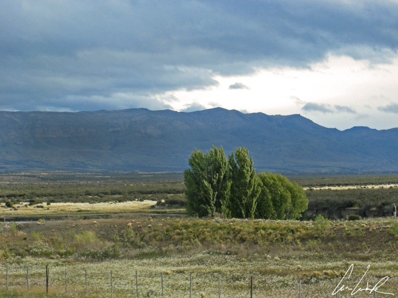
Back on the mainland, we leave behind the ice age (still no Scrat and his nut ?) to descend upon the steppelike plains of Patagonia with their small thorny shrubs and herbs. The bush, formed mainly of the species Larrea divaricata Cav. and Stipa sp, stretches out again in front of our eyes, creating small islets scattered randomly… a long road towards the stunning Torres del Paine National Park in Chile.


So beautiful! It’s at the top of my bucket list and your photos are amazing
Thanks :-). An extraordinary adventure I recommend to you… You should see it by yourself at least once !
So informative and your pictures are lovely! Thanks for sharing.
Thank you ! This place is so beautiful… so I really wanted to share lovely pictures 🙂 to inspire people to be adventurous and to go to Patagonia !
WOW!!! What a beautiful sight… It’s on my top bucket list but I just couldn’t find time to go:( How many weeks you think needed to explore that part of the world?:)
If you are a Nature lover, this place is definitively for you :-). I spent only 3 days in this specific area (Los Glaciares National Park / El Calafate). We stayed 2 weeks to visit Patagonia (both Argentina & Chile)… it is a short time but it gave us a good overview of the different places.
Wow! Those ice blocks floating in the water are absolutely gorgeous! Your photos are beautiful, thank you for sharing 🙂
Thank you :-). The boat passes monstrous icebergs adrift, sculpted by sun and water into fantastic shapes ! The play of light creates a beautiful palette of subtle hues. It is an amazing experience !!
It must’ve felt so special to see these majestic icebergs! I just love those shades of blue! This has been on my bucket list for so long that maybe it’s time to do something for it – thanks for the inspiration.
This is a unique experience ! We encounter dozens of icebergs adrift, so gigantic in height, sculpted by sun and water into fantastic shapes… Each has its own style changing in the light from translucent to deep blue. You should definitively plan a trip there, you will love it 🙂
These pictures are amazing! I’m not a fan of cold, but this would make it totally worth it!
Thank you :-). If you have a look at the average annual temperature: it is 40 °F and the Summer high never over 63 °F… Take a warm coat with you !
Wow, this is absolutely amazing!! Patagonia is an area I always wanted to visit, especially because it wasn’t so far away from me as I am from Brazil and I lived there, but now that I moved to Europe is not that easy anymore. I’ll have to plan it and try to visit next time I go home for holidays. Perito Moreno is so incredibly beautiful, can’t wait to see it!
Yes, Patagonia is an incredible place to visit ! You should see it by yourself at least once :-). The Perito Moreno Glacier is a gigantic mass of ice in the heart of the Los Glaciares National Park. We feel minuscule in front of this massive ice field creaking and grinding as it slowly advances…
Oh wow, this is definitely on my bucket list and your photos are amazing! I visited the Pastoruri Glacier in Peru but it looks nothing compared to this! 🙂
I’ve never been to Peru yet (on my bucket list) :-). I have also seen quite a few Glaciers before (in Switzerland & in Canada) but I totally agree with you: the Perito Moreno is definitively a unique and incredible experience !
I never saw an iceberg before, seems you had a fantastic adventure. Love the photos…on my list now 🙂
It was also my first experience which such monstrous icebergs adrift ! And you’re right, it was really a fantastic adventure 🙂
Absolutely stunning photos, Celine! I think it’s incredible that we only see the tip of the iceberg, I really hope that our generation and future generations can protect this landscape and nature!
I hope that we can pass it on to the next generation as well 🙂 Nature gives us so many things for free – clean air, clean water, beautiful …
WOW!!! I’d definitely add this on my bucketlist. This is just stunning, and your photos are just amazing
You should definitively plan a trip there, you will love it ! It is an amazing experience to pass monstrous icebergs adrift 🙂
So beautiful! I’ve always wanted to visit Patagonia but worry about the climate. Looking at the photos, I guess I should start planning again 🙂
Yes, you should definitively plan a trip to Patagonia, you will love it ! Just take warm clothes with because the Summer high temperature is never over 63 °F…
WOW! I’ve never seen anything like this up close! I feel like it must be a very humbling experience. Added to the bucket list!!! xx
Indeed, this is a very humbling experience :-). Just take a warm coat and enjoy the place !
We loved visiting Perito Moreno! It was so interesting, and getting up close on the boat was amazing. Did you make it to El Chalten? That was our favorite spot in Argentine Patagonia <3
Perito Moreno Glacier is undeniably spectacular and coming to Patagonia without visiting this blue-hued natural wonder would truly be a shame 🙂 I fully agree with you… We highly recommend doing the boat ride right up to the glacier, it’s an experience that’s far more impactful than just observing it from the walkway ! Unfortunately, we did not have enough time to go to El Chaltén, which boasts the famous Fitz Roy. It gives me an excuse for a return visit 😉
Perito Moreno continues to be one of my favorite activities that I’ve experienced. We hiked on the ice and had so much fun. Unfortunately, we didn’t have time for the boat ride, but all the more reason to go back. The Pataganonian lamb is one of the best food experiences in Patagonia. A definite add for any traveler to the region. Great article.
Thank you 🙂 There is perhaps no more spectacular place than a glacial lake. Cruising through the icy waters of Los Glaciares National Park in Patagonia, I could only imagine what the earliest explorers felt when they came across this frozen land thousands of years ago. Untouched, clean and pristine !!