Sæll,
Hvad segirdu gott? Me, Það gengur vel! If you are still interested in enrolling at the school of elves, you need to work on your Icelandic… But let’s resume our journey to the heart of this mysterious island, so dear to Jules Verne. Lake Mývatn or “lake of midges” is a picturesque eutrophic lake located in the Northeast part of Iceland near the Krafla volcano. The name of the lake comes from the high number of aquatic insects, the “Chironomidae”, much like mosquitoes and commonly confused with the latter, found in the wetland around the lake in the summer. These Diptera do not bite, but have the nasty habit of appearing everywhere as soon as we stand still for a few moments… The lake itself is a paradise for birds. You can see without difficulty the little Harlequin duck, the Great Northern Diver, and the Barrow’s Goldeneye, all common species. South of the lake, are the pseudo craters of Skútustaðir. These rootless cones resemble a true volcanic crater, but the vent has never ejected lava. They were created 2,000 years ago by steam explosions that took place during contact with lava over lake water. When the lava covered the lake the water turned into steam, and the pressure pierced the crust of the viscous lava. The exploding gasses broke the lava’s surface, like the bubble in mash potatoes on the stove, forming a pseudo-crater.
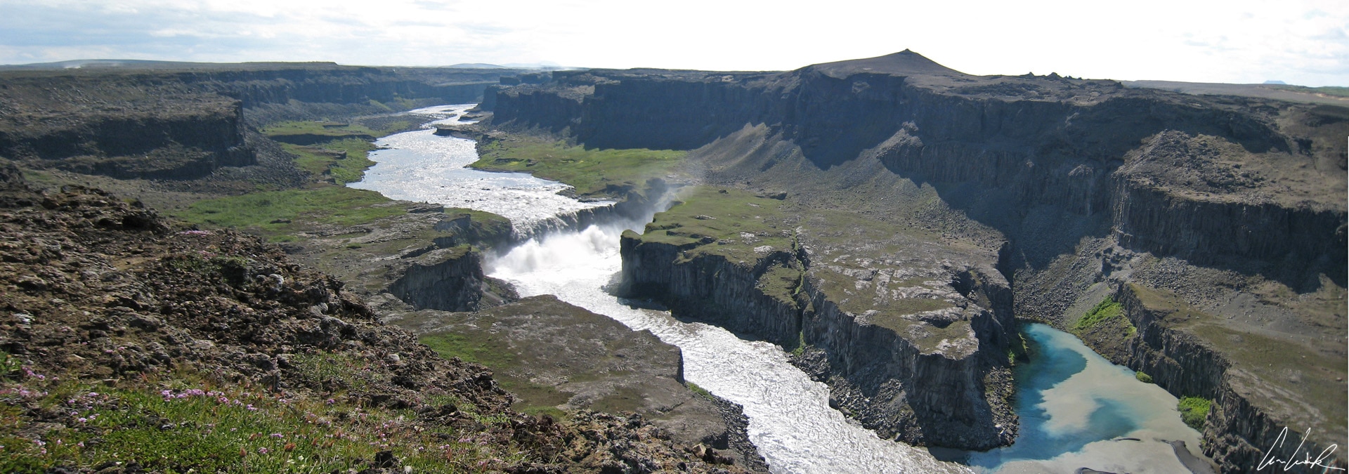
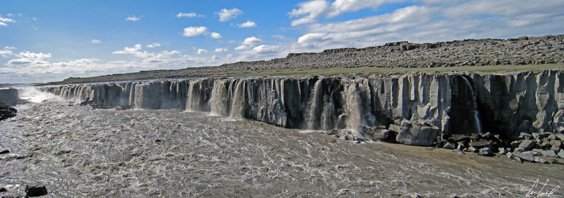
Hafragilsfoss Waterfall
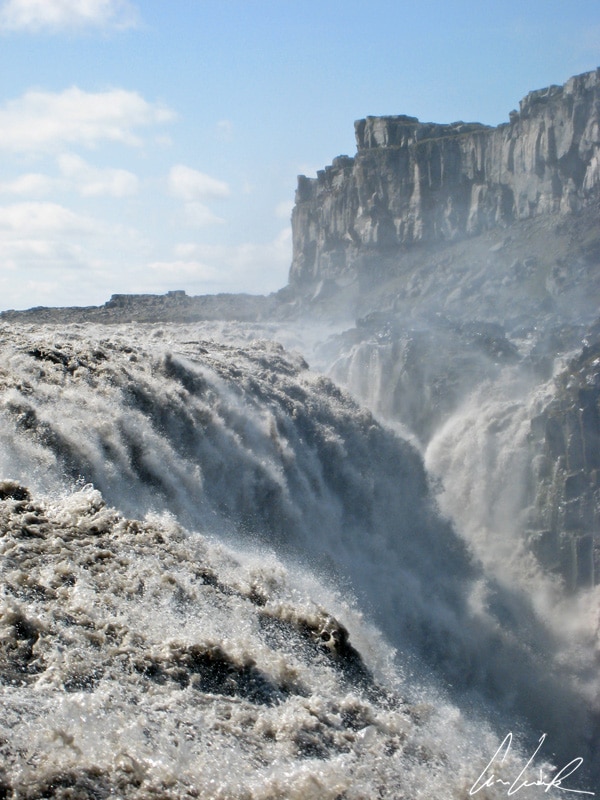
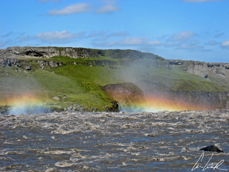
Waterfalls, again and again ! The river Jökulsá á Fjöllum (or “glacial river Mountain”) in the Northeast of Iceland, is the second longest river in Iceland. It flows 128 miles from its source in the Vatnajökull glacier to the Greenland Sea. The river has three major waterfalls, the three musketeers, answering the sweet names of Dettifoss, Selfoss, and Hafragilsfoss. Each of the three cascades has a unique personality and story. Dettifoss, with its brownish water, is the most powerful waterfall in Europe with an average flow of 6,816 cu ft/second. It drops 148 feet down to the Jökulsárgljúfur canyon, carved in basalt and 330 feet wide. It is certainly one of the most famous and arguably one of the most visited waterfalls in Iceland. Upstream we have Selfoss, a cascade consisting of a multitude of small waterfalls with an average height of 36 feet. Two miles downstream from Dettifoss is Hafragilsfoss, a-89 foot high waterfall about 300 feet wide, with a breathtaking palette of colors. The tumultuous flow of water came from the melting of the Vatnajökull glacier and carries tons of glacial debris that give the water a brown and dirty appearance…
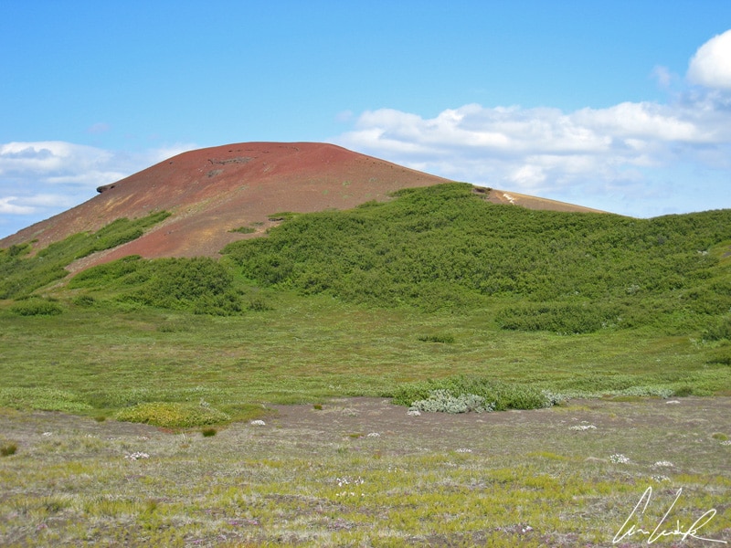
Up the course of the Jökulsá á Fjöllum towards the South lies Ásbyrgi canyon. This horseshoe shaped canyon is about 2 miles wide and a half mile across. Only an aerial view reveals the shape of the arc. According to legend and Norse mythology, it is the footprint of Sleipnir, Odin‘s eight-legged horse. Given the dimensions of the canyon, we imagine the enormity of this mythical horse. In reality, the canyon was formed thousands of years ago by cataclysmic glacial flows into the river Jökulsá á Fjöllum from the Vatnajökull glacier. At the heart of this canyon, we find a small lake with green tints named Botnstjörn, surrounded by abundant vegetation including a birch forest. From the top of the Rauðhòlar, a superb mountain with red and black sides that contrast with the bright green of the moss growing on volcanic rocks, we enjoy a spectacular view of the gorge Jökulsa and the forests surrounding Ásbyrg.
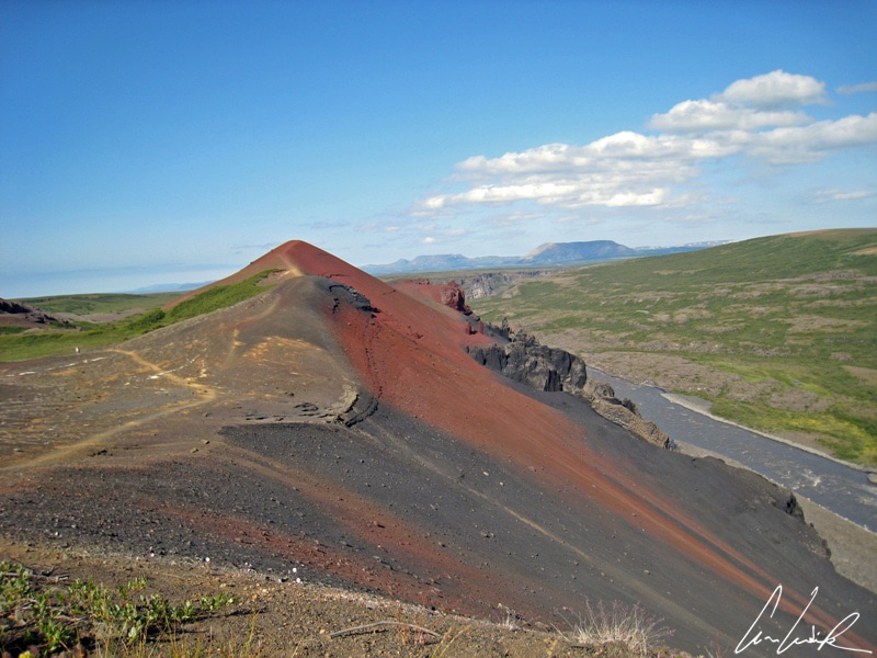
Volcan Raudholar – With red and black sides
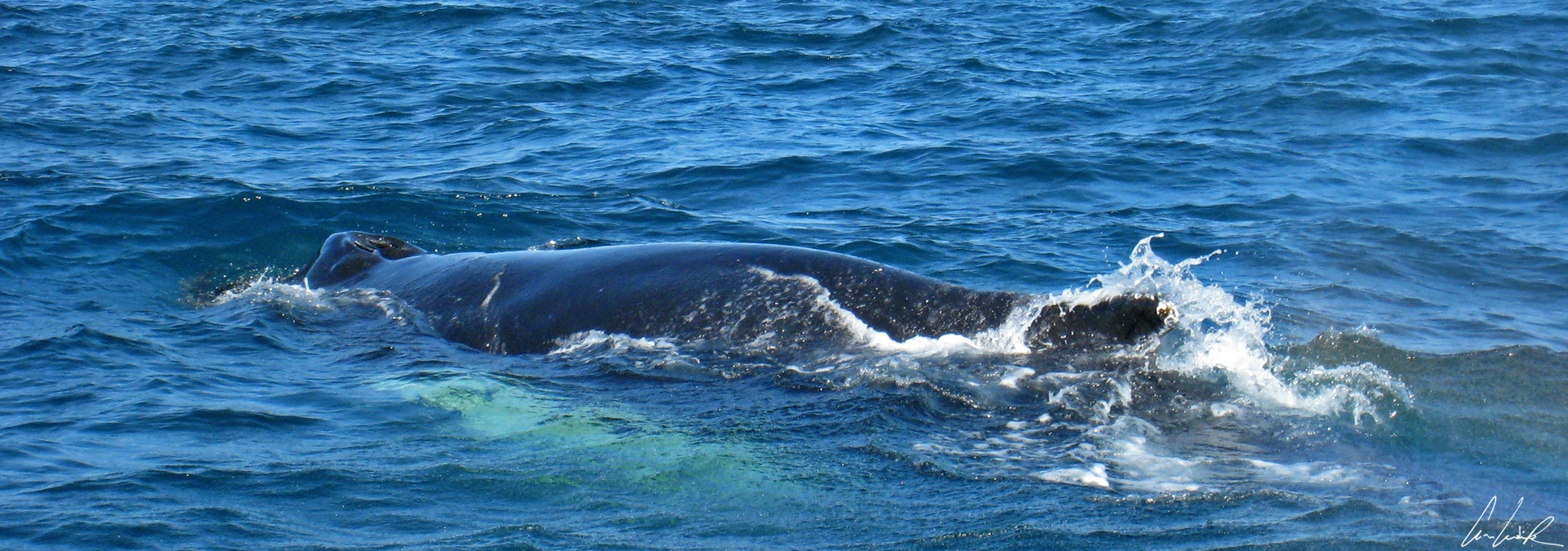
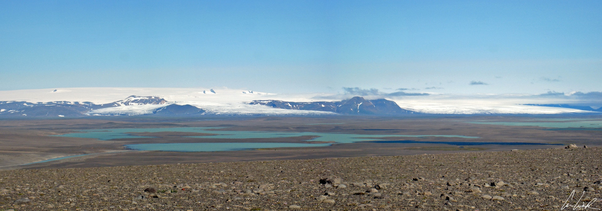
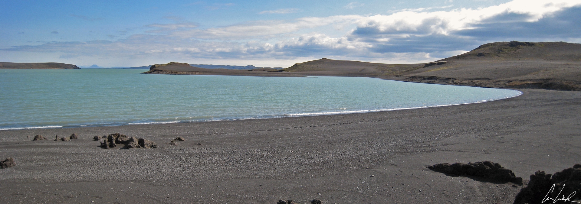
A quick return to civilization before journeying to the center of the Icelandic earth. Nestled by the shore of Skjálfandi Bay in the North of Iceland, the town of Húsavík is recognized around the world as one of the best sites for whales watching. Wooden fish racks signal the proximity of Husavik, a fishing port that smells of the Big North or, rather, of codfish. From the town we have a magnificent view of the fjord and the snowy mountains in the background. Let’s go to the interior high plateau…! The landscape of the desert of Sprengisandur is moonscape made of volcanic rocks lying on the bare ground or half-buried in volcanic ash. Now and then the road runs along a lake completely free of vegetation, similar to Lake Porisvatn at the South end of Iceland. The view stretches into the distance over the sparkling glacier icecap. The sparse vegetation clusters around streams where fluorescent green moss and pink Fireweed form a stark contrast to the surrounding gray. You have to cross many narrow fords (about 10). At some you need to check first where the shallow spot is, but by following the right path we can cross all passes easily. Even a waterfall (the next to the last one – I promise) graces the next to the last fjord. The Aldeyjarfoss waterfall is in the valley of Bárðardalur about 56 miles from Húsavik. It runs into an old lava field, revealing magnificent black basalt columns covered with orange lichens contrasting with the white foam of the fall. There are two clear, superimposeded layers of basalt. The upper layer is irregular and chaotic because the lava cooled rapidly while the lower layer has regular columns. The latter cooled more slowly, allowing a smooth contraction of the lava.
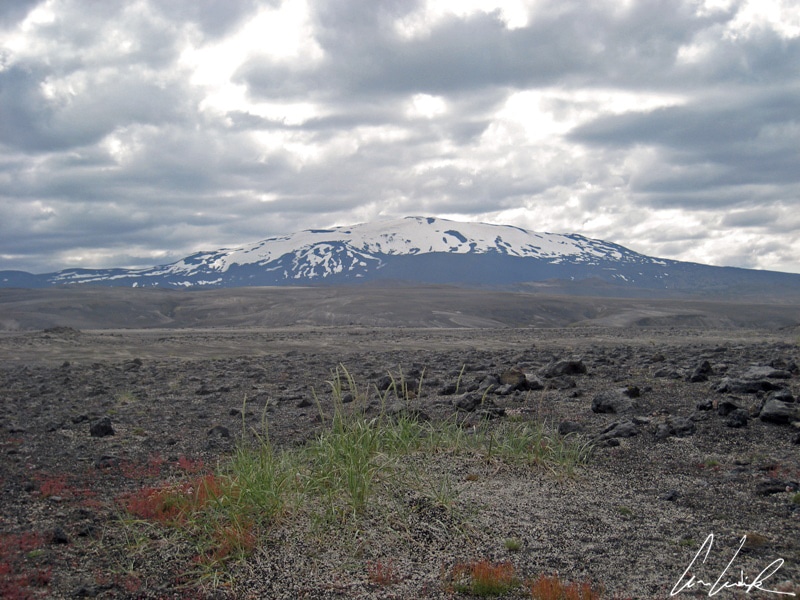
From its height of 4,892 feet, the black mass of the Hekla volcano, 68 miles East of Reykjavik, dominates the South of Iceland. It is the best known and most feared of all the active Icelandic volcanoes. It had a bad reputation and was long considered the gateway to hell along with the Stromboli. Its summit was only conquered in 1750, and pioneers, who found no trace of the devil, opened the path of ascent when the weather is clear. Its snow-covered summit is frequently in the clouds. This volcano is active. There have been over twenty eruptions since the first recorded in 1104. Alternating explosive and effusive phases, Hekla is able in a single outbreak to expelling huge amount of rhyolitic ash and tephra plumes of several miles into the atmosphere while spewing lava fountains. Hekla has killed and will kill again, burying farms, poisoning pastures and rivers with fluorides, throwing huge rocks to several miles. Its eruptions are difficult to predict because the seismic activity starts only about an hour before eruption.

Frostastadavatn Lake
Near the Landmannalaugar camp in an austere and barren landscape of tiny volcanic projections (lapilli) and scattered blocks, surrounded by small bare mountains, covered with a downy moss and lichen, lies the lake Frostastaðavatn in which reflected a rhyolite orange and green mountains, the Suðurnámur. The set takes an even more daunting aspect on a gray, rainy, cloudy day and by high wind, hiding the outlines of the landscape, only discovering it during a short lull. Iceland is also the unpredictable weather and a tireless wind, hence the quip, “if you do not like the weather, wait ten minutes.” The interior is a vast and austere territory, harsh climate, uninhabited, except perhaps by trolls but it is probably the most beautiful part of Iceland. Landmannalaugar is an explosion of colors, unusual shapes, a variety of sceneries and geological features. The colors are extraordinary, a chromatic richness to make any painter green with envy, black, pale yellow, bright yellow through blue and red. We enter another planet, an absolute breathtaking dream world, and sight, sulfur, rock, and lava field. Landmannalaugar is famous for its hiking trails, the scenery and atmosphere are changing as the hour, the weather and the season. It is a total immersion in nature, in a stunning valley between colorful rhyolite mountains and lava field called Laugahraun. At the foot of the Laugahraun, we bath in a stream fed by springs of hot and cold water, lost in the middle of grass fields, buttercups, and Arctic cotton grass…
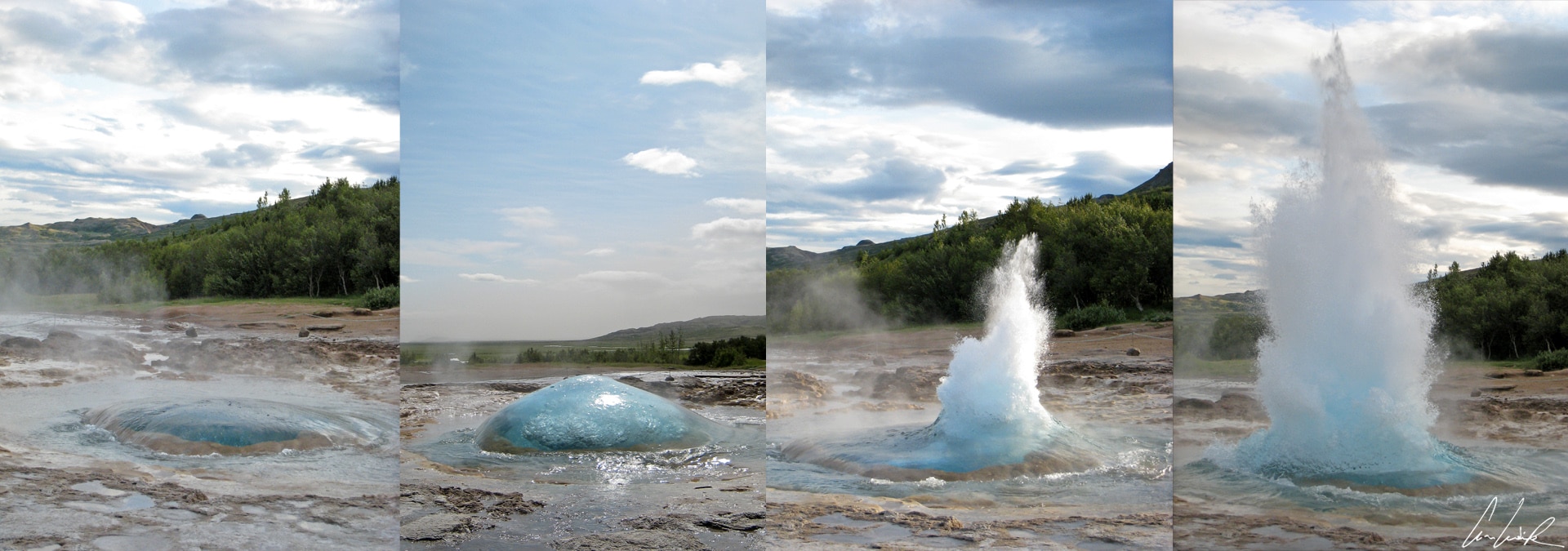
Geysir – The Strokkur
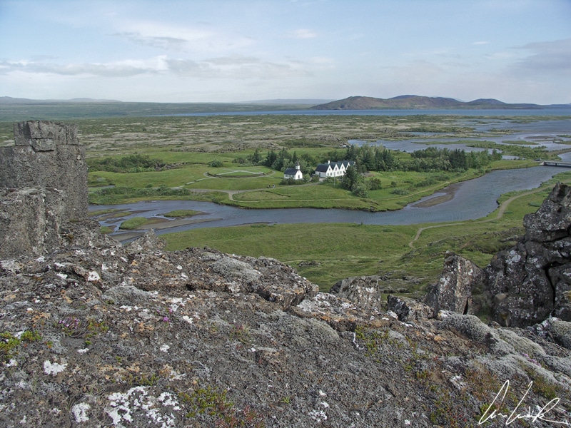
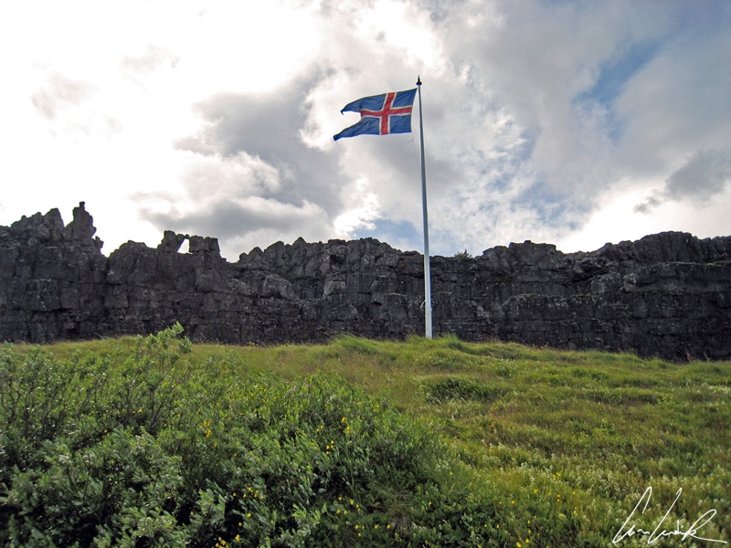
After this adventure in the center of Iceland, I propose to end the journey with the “Golden Circle,” the most famous tourist route in South of Iceland. The 190-mile loop includes the Thingvellir National Park, Gullfoss Waterfall, and the Geysir geyser area. The Gullfoss waterfall, meaning “Golden Falls,” is located in the canyon of the Hvtà river (“White River”) in Southwest Iceland. Gullfoss waterfall flows through three successive steps before a drop of 105 feet into a narrow crevice lined with black basalt. The second stop on this private and popular circle, the Geysir geothermal area, is in the Haukadalur Valley, East of Reykjavik. The geothermal valley is home of the Geysir also known as The Great Geysir and Strokkur. The Geysir whose name is derived from the Icelandic verb geysa “to gush,” gave its name to all geysers worldwide. In the 1900s, Geysir could regularly spout boiling water 196 feet up into the air. Since the 1980s, eruptions can be stimulated by the addition of soap, which aims to lower the surface tension of water and thus facilitate the transition from liquid to gas. Nearby, the Strokkur meaning “churn” has the regularity of a metronome. Erupting approximately once every eight minutes, the geyser Strokkur spouts a water column up to 98 feet into the air to the delight of photographers. But what is most appreciated is the gorgeous turquoise bubble that pops up just before the steam. No other geyser presents this feature! To complete the Golden Circle, a visit to the Thingvellir, in Icelandic Þingvellir, is inescapable. Thingvellir National Park was established in 1930 and became a World Heritage site in 2004. This site is of great historical and geological interest. Here we witness live the continental drift between North America and Europe. Each continent is on a different tectonic plate. The Almannagja fault, a veritable canyon, traverses the landscape for many miles. In this spectacular scenery, Icelandic people established the Althing (Alþing), an outdoor assembly. Founded in 930 at Thingvellir it is the oldest Parliament in the world and about 22 miles from what later became the capital of Iceland, Reykjavik. The Parlement remained at the same location until 1798. At the center of the assembly was the Lögberg or Law Rock, a rocky outcrop in the middle of the field where the judge (lögsögumaður) took his seat. He advised goðar, farmers, and merchants and recited aloud the laws in effect at the time and proclaimed the procedural laws of the Althing. The Icelandic constitution is unique in its time: no police, no army, no king but only a distribution of power between the boendr (farmer leaders) who are responsible for defending the interests of the people in their district.
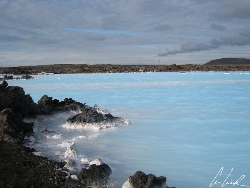
Finally, no tour of Iceland would be complete without a bath in the Blue Lagoon (or Bláa Lónið), a must-do experience. The Blue Lagoon is located in a lava field on the Reykjanes peninsula, about 24 miles from Reykjavik. The decor of Bláa Lónið is unrealistic: imagine a surface of incredibly blue water lost in the middle of lava fields and, as background, the whisper of steam from the geothermal plant nearby. You bathe and swim outdoors at rather chilly temperatures, but are in water between 99 and 102 ° F and encircled by a cloud of steam. The waters of the Blue Lagoon come from underground reservoirs superheated by the magma to 464° F and piped into the Blue Lagoon at 158° F. The water is rich in minerals including silica and sulfur, and blue-green algae, which gives it a milky turquoise color even in bad weather… Bathing in this water is said to help people suffering from skin diseases including eczema and psoriasis. We leave Iceland cured of all illness… but these are just words!
Við sjáumst!
Discover my others articles about Iceland


I’ve never been to Iceland, but it looks absolutely beautiful on your pics! I will have to add this to my bucket list and visit it some day!
Iceland is otherworldly ! It is a unique destination that offers unspoilt nature, breathtaking landscapes and vibrant culture 🙂
Great photography, will have to do this once!
Thank you 🙂 . You should see this amazing place by yourself at least once !
What it takes to join on your next trip ??? Amazing clicks . Love to feature them on our Website too
Thank you. My next trip to Bhutan is planned for end of September. Feel free to join 😉
Wow, Iceland has enticed me a lot, and now your post & pics have jittered me out! Lemme see how early can I plan there!
Most people come to Iceland to admire the nature – and it’s no wonder why ! There are picturesque glaciers, rivers and waterfalls just a stone throw away from colourful beaches, lush valleys and deserts. Even volcanoes underneath glaciers and hot springs surrounded by ice.
2,000 years ago? wow that’s so impressive! Amazing photography skills, well done!
Iceland is so staggeringly beautiful and otherworldly ! Everywhere you turn there are glaciers, waterfalls, lava fields, rainbows, streams and mountain ranges. With every turn of your head, you’ll feel like taking a picture 🙂
Great pictures. It is one place which I really want to visit. Thanks for sharing the details with us.
For amateur photographers as well as professionals, Iceland is the location that can present you with some of the most amazing photo settings you’ll ever witness!
Wow what an amazing experience! I would love to visit Iceland and you pictures are amazing! I will have to add this to my travel bucket list after this post! Thanks for sharing.
The country may be small but it is very rich in nature and culture and filled with contrasts 🙂 Iceland is full of so many amazing places to see, great people to meet, delicious food to eat etc. so see it by yourself at least once !
Well written article with very very beautiful pictures. Thanks for this lovely post
Thank you 🙂 You’ll be sure to find your picturesque opportunities in Iceland ! It is so rich in nature and filled with contrasts. Imagine a black sandy beach and crashing waves on peculiar rock formations. Next to it are green fields dotted with colourful flowers – and to top it off, a shimmering white glacier as a backdrop. It’s really photographer’s dream destination !
This is so cool! Ive never heard of anything like Iceland before! Cannot wait to try it out!
Iceland is the perfect destination for outdoorsy travelers hoping to tap into the region’s enchanting landscapes !
Super gorgeous photos! I’ve never been to Iceland, but it’s a dream to go someday!! I’ve always thought it’d be beautiful – especially for my photography 🙂
Iceland is known for its otherworldly beauty, a landscape that includes extreme contrasts, all in one melting pot. Iceland is a photographer’s dream destination 🙂
Such a beautiful Photography in a beautiful location, would love to visit one day.
With every turn of your head, you’ll feel like taking a picture. No matter what you like to photograph; nature, animals, people, daytime, nighttime, midnight sun, northern lights… you’ll be sure to find your picturesque opportunities in Iceland !