
“Hau”, as we say in Lakota language !
South Dakota can be considered both as part of the Midwest and of the Great Plains regions. The state’s name is taken from the Lakota and Dakota Sioux Native American tribes. The Missouri River divides the State into two geographically and socially distinctive regions, east and west. Between May 1804 and September 1806 the Lewis and Clark Expedition – nothing to do with the “Lois and Clark” series even if one could call these two men “Supermen” – successfully navigated the Missouri River to cross the West of the United States. Starting at Camp Wood, Illinois, theirs was the first expedition to reach the Pacific coast in Oregon. South Dakota is characterized by vast gently rolling hills and plains. The monotony of this landscape is only broken by the Black Hills, a mountain range in the southwestern part of the State. Within the Black Hills, Black Elk Peak at 7,242 feet high, is the state’s highest point. If the iconic image of Laura Ingalls running across the prairie comes to mind… you are both right and wrong ! Why ? Because the series “The Little House in the Prairie” was filmed in Walnut Grove in Minnesota, the neighbor’s State to the East… but the real Laura Ingalls Wilder lived in the small town of De Smet in South Dakota where the adventures of Little House took place. Her successful autobiography was the source of the television series… If you are looking for 100% South Dakota scenery, think instead of the 1990 movie “Dances with Wolves” starring Kevin Costner and the novel the same name by Michael Blake. Bingo, you are transported into the atmosphere of the place… a landscape characterized by nature, history, the Black Hills and the big reservations of the Native-American Sioux tribe… Visiting South Dakota is to wander on small roads and to dive into another America. It is a very nice discovery for all lovers of the American West, the real West !

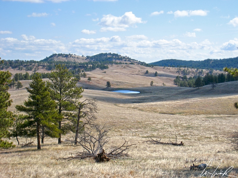
Wild Life Loop Road, prairie
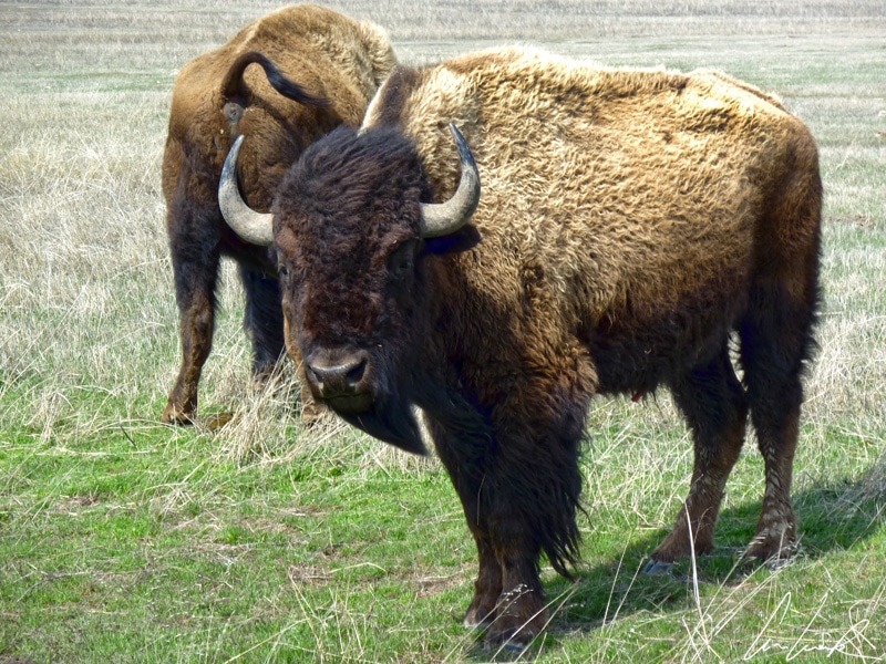
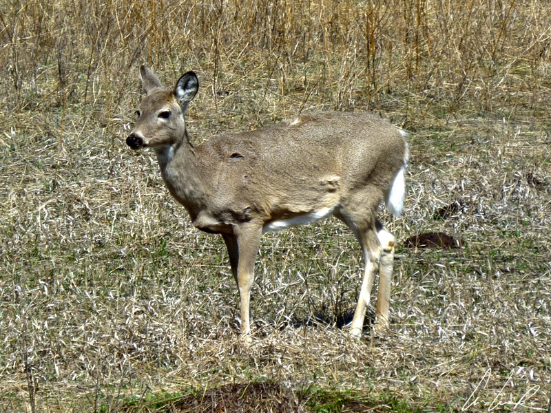
Custer State Park is South Dakota’s first state park and the largest in the United States. It was established in 1912 and named after George Armstrong Custer, an American cavalry general best known for his defeat and death in the Battle of the Little Big Horn, Custer’s Last Stand, in 1876 during the American Indian Wars. The park covers 71,000 acres of hilly terrain and grasslands and is located in the Black Hills southwest of Rapid City. In the early morning, we take the “Wild Life Loop Road“, an 18-mile scenic byway that allows you to discover the hilly part of the park. An afternoon drive allows you to observe the best of the wildlife. Many animals roam freely, including the famous “Thathanka” (buffalo in Lakota language). The road winds through pine-covered hills and prairies in a strange silence… Time moves slowly. Mother-nature awakens gradually as the “wi” (sun) appears timidly at the horizon. Then we see some movement, at first indistinct, in the distance, but as we get closer… impatience seizes us… a little cloud of dust grows and suddenly we are surrounded by a peaceful herd of buffalos ! Of course, it is nothing like the famous scene in “How the West Was Won” (1962), which was filmed in the park, showing Native-Americans releasing a herd of bison to destroy a village of settlers. Finding yourself face to face with the largest mammal in North America is astonishing. Do not be fooled by the buffalo. Despite its size – it can weigh up to 2,000 pounds – it runs up to 40 mph. We quietly continue our journey, leaving these herbivores to their breakfast… The grassland is still full of other surprises such as “Kakiya,” mule deer and white-tailed deer named for the size of their ears—as big as those of a mule—and the color of their tail. A little further away are the “lel” or prairie dogs. With short legs and a stocky body, this little sentinel looks like a groundhog. It can dig burrows up to 15 feet deep thanks to its long sharp claws which also protect against predators.

Wild Life Loop Road, buffalos
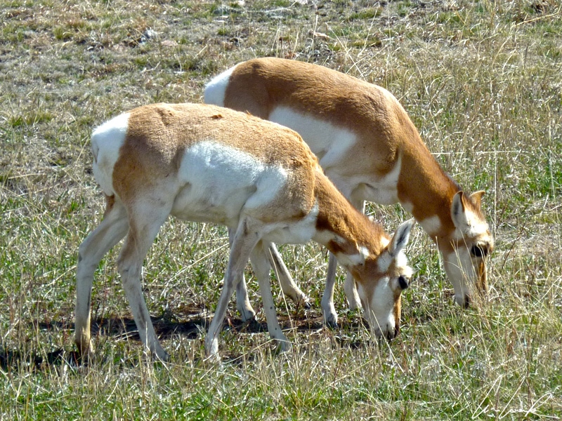
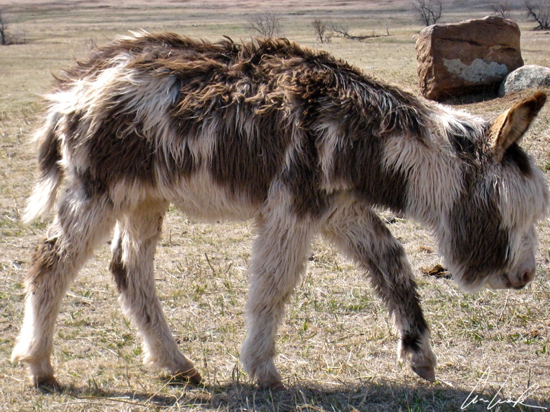
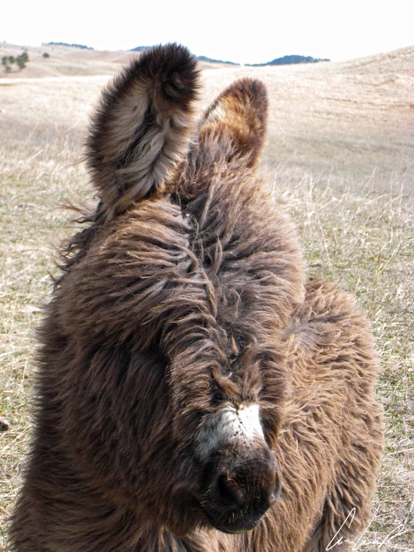
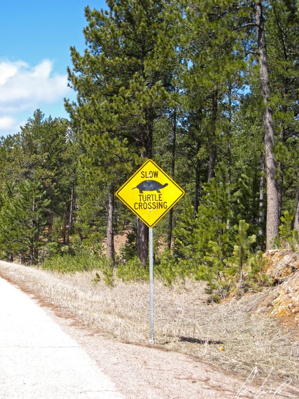
We drive slowly through the park, enjoying and marveling at the scenery and wildlife. Oh, look at these strange animals with white fur on their rumps, sides, breasts, bellies, and across their throats, and nicknamed “White Ass” but more commonly called Pronghorn (Antilocapra americana). They resemble antelopes found in Africa. This is the only antelope native to North America. Its eye sockets are prominent and set high on the skull. They also have a 320° field of vision and allow the Pronghorn to detect movement several miles away. It is one of the fastest land mammals reaching speeds up to 50 mph to escape predators. Leaving behind the Pronghorn, we now enter the territory of wild “burros” (wild donkeys), which, not so wild, beg for snacks from passing vehicles… During the gold and silver rush, prospectors relied on burros as they can tolerate harsh desert conditions. Later these hairy donkeys transported visitors to the summit of Black Elk Peak (formerly Harney Peak). Nowadays, these adorable burros wander freely using charm to get food… Near the partly frozen Lake Stockade we witnessing the highlight of our animal show: a Rocky Mountains Goat with white fur for camouflage poses for us. Mountain Goats are outstanding climbers, commonly seen on near-vertical rock walls… Clic, clac, we take a picture, but, be assured, we were not that close. It is forbidden to approach wild animals in the park. There are some safety distances to respect for each animal, and with some it is better to keep some distance… Near Lake Stockade a wildlife warning sign asks us to drive with caution… Which animal is featured on the sign ? Deer ? Moose ? Bighorn Sheep ? Not at all, the sign warns of turtles. Why does the turtle cross the road? Always the same answer: because the grass is always greener on the other side … It seems that at certain times of the year, turtles try their luck crossing the road to get from Lake Stockade to a small swamp on the other side of US 16A.

Lake Stockade
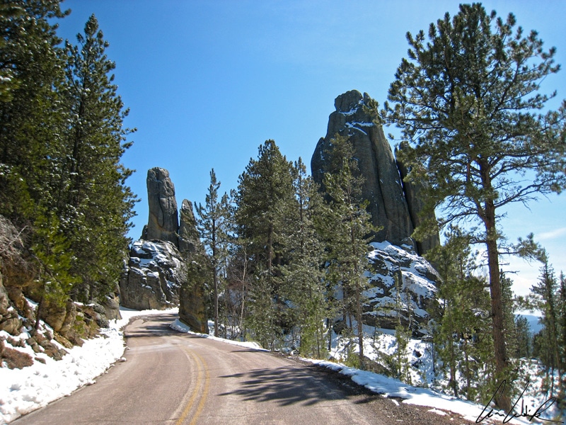
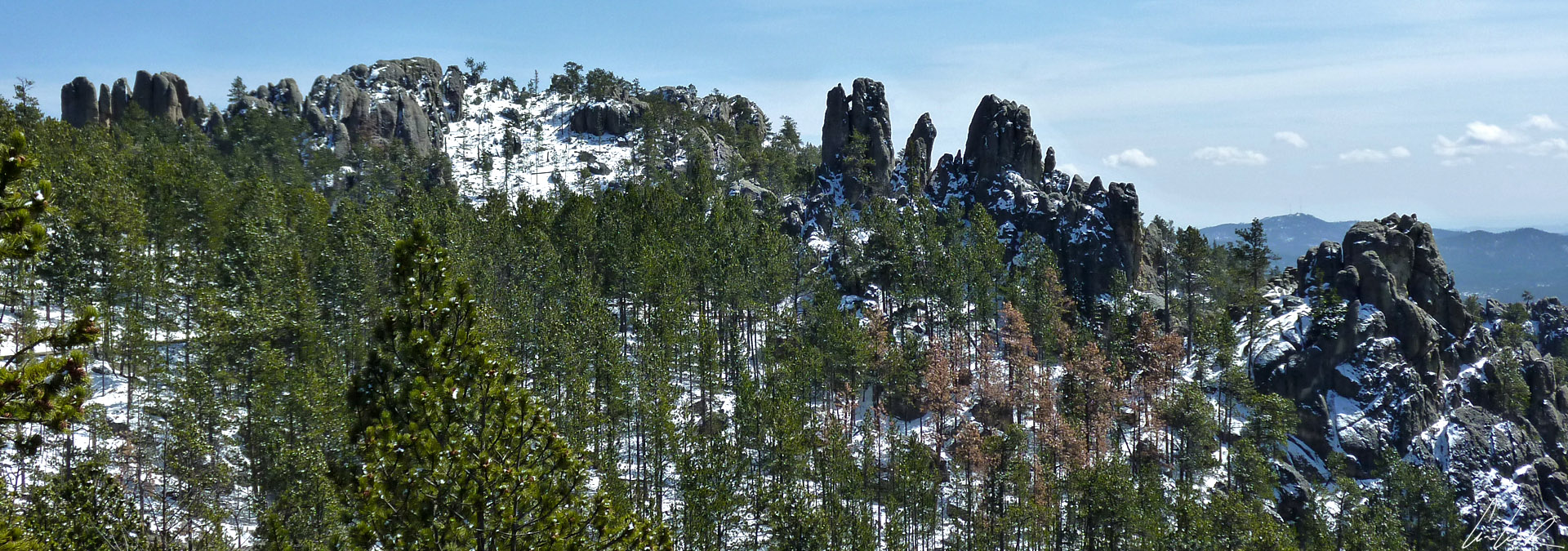
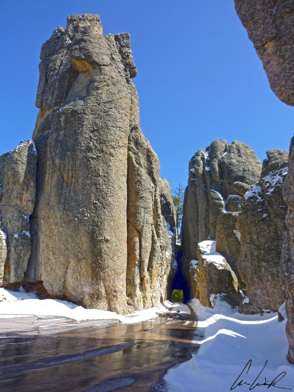
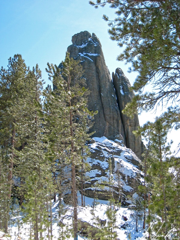
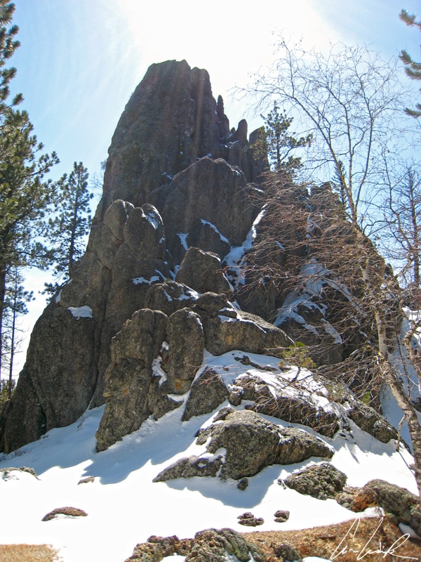
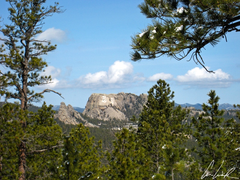
Besides an unforgettable and “oowanyanang wasté” (beautiful) encounter with one of the most mythical animals of the west, the “Thathanka”, Custer State Park also offers the opportunity to discover the picturesque landscapes of the Black Hills. The black hills are so-called because of their dark appearance from a distance. In the northeast of the park, South Dakota Highway 87 is known as the Needles Highway Scenic Drive. It is a 14-mile road crossing the Black Hills through pine and spruce forest, meadows, and granite formations and offering spectacular views of eroded rock formations. The dark forests of ponderosa pines and the famous granite needles make the land sacred to the Lakota Native-Americans. For the Lakota, “Paha Sapa” and “He Sapa” (Black Hills) are the center of the world, “The Heart of All There Is”. Just about 30 miles south of Rapid City, Needles Highway Scenic Drive was completed in 1922 and includes sharp turns and three small tunnels carved into granite walls that limit the size of the vehicles: Hood Tunnel (10’6” wide by 10’7” high), Needles Eyes Tunnel (8’4” wide by 12’0” high), Iron Creek Tunnel (9’0” wide and 12’3” high). Throughout the drive, you can admire the famous granite needles, geological curiosities sculpted by erosion, which make the area famous. To end the trip in style, take a break and a stroll along the shores of Lake Sylvan, created in 1881 after the construction of a dam across Sunday Gulsh Creek. Lake Sylvan was added to the park in 1921, and nicknamed the “Crown Jewel” of the Black Hills ! In season, the lake area offers many outdoor activities: rock climbing, swimming, rental of canoes and boats, fishing, hiking trails… If the lake seems familiar, it might be because you saw the Disney’s 2007 film “National Treasure: Book of secrets”… but contrary to what the film suggests, the lake is not directly behind, but 5 miles southwest of the Mount Rushmore National Monument (Ah, the magic of Hollywood) !

Needles Highway Scenic Drive
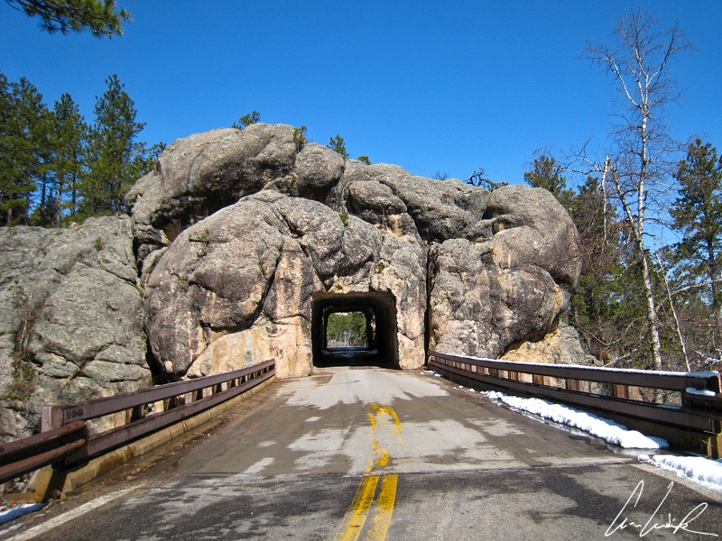
Finally, a visit to the park would be incomplete without a stroll on the Iron Mountain Road. In addition to beautiful pine forest landscapes, this 20 miles scenic drive is best known for its 3 small tunnels and 3 “Pigtail bridges”, spiral wooden bridges that allow you to climb quickly up the hillside. As for the three short tunnels, carved into the rock, they are narrow and not very high: the Scovel Johnson Tunnel (13’4” wide by 12’4” high), the CC Gideon Tunnel (13’2” wide on 12’2” high) and the Doane Robinson Tunnel (14’0”wide and 12’9” high). Let me tell you a little story. Jonah LeRoy “Doane” Robinson (1856-1946) was the state historian of South Dakota who first suggested the Mount Rushmore National Memorial. The Doane Robinson Tunnel is famous for the exquisite view it offers on this monument!
“Tókša akhé” (see you in Lakota language)


I went to South Dakota last year, but I missed this one! It’s so pretty there.
It gives you an excuse for a return visit 😉
Wow, love the place and very amazing shots you got there. I would love to visit there someday. This kind of places makes my bucket list longer. I have another one to add into it again.
There is ample opportunity to view scenery as well as wild life ! The wild life loop drive is a nice slow pace to enjoy the wild life and the views along the way. Don’t just drive the blacktop road also drive on the gravel roads to see even more of the interior of the park 🙂
What an amazing experience. A safari has always been on my bucket list and I always thought I would have to go to Africa to have an amazing experience. This post has definitely widened my ideas. Your pictures have definitely sold this one for me; animals and beautiful nature.
Thank you 🙂 Wildlife Loop Road travels through 18 miles of colorful wildflowers, prairie grasses and pine-speckled hills. Depending on the day, you might see bison, pronghorn, whitetail and mule deer, elk, coyotes, burros, prairie dogs, eagles, hawks, and a variety of other birds… A real “Safari” experience !
What an awesome post! I’ve never considered visiting South Dakota and had no idea that this park existed, but I’m definitely adding it to my list!
One of the most overlooked and underrated states in the US is South Dakota ! While discovering off-the-beaten-path treasures, the inherent thread of Wild West history piques one’s curiosity, fueling the desire to explore some more 😉
I love the outdoors and this looks like my kind of place. By the way I really like your writing and I would prefer a bit bigger font size for your posts 🙂
Thanks Chris ! I will check what I can do for the font size 😉
Safari in America- that’s something unique I have heard! Never heard about this place before but I would like to explore this safari for sure.pics are great. Thanks for sharing.
Thank you 🙂 South Dakota is known for wild animals such as bison, mountain goats and big horn sheep, but we’re also home to some unexpected critters. Various attractions throughout the Black Hills offer amazing experiences !
Lovely post. I didn’t know about the place but your pictures want me to visit. We have such parks here in India, although at a little higher altitude. If you are visiting let me know
I’ve only visited part of the Rajasthan in India but it was a wonderful experience ! You have to visit Custer Park for its remarkable beauty, its thrilling animal encounters and its incredible scenic drives 🙂