First, let’s set the background! Iceland is a Nordic island country of 39,699 square miles near the North Pole. It opens to the inside of the Earth, and the Sun does not set during the summer… The grandiose and deserted landscape is crisscrossed by rivers and streams. Iceland, with a population of 332,529, is the most sparsely populated country in Europe, 8.29 people per square mile. Reykjavik, the capital, and the largest city has 120,000 inhabitants. Iceland is a land of fire, water, and ice where travelers feel insignificant and humble. Here, solid ground is not always present: a simple pit may hide a devil’s pot, a green pasture one day can turn into a lava field the next day… Geysers erupt from the earth, and the sky blazes with the Northern Lights during certain periods of the year. The smell of sulfur and the origin of the world hovers over the land. A Land of extremes once considered the door of Hell; Iceland has forged a wild identity, mysterious and mesmerizing…
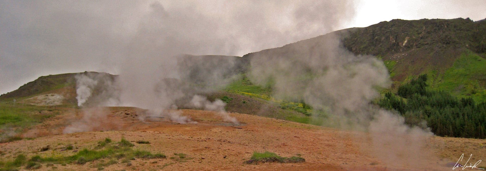
Hveragerdi
This small republic between the North Atlantic and the Arctic Ocean where it is possible to take a bath at 102°F in one of its famous hot springs, would not exist without a touch of madness from mother nature. This wild land attracted Scandinavian Vikings in the late 9th century. They established a unique civilization between fumarole fields and mud pots and created a rich mythology of trolls and elves… To help your mind to assimilate this mystical atmosphere, let it be soothed by the melody “Going Home” by Heimförin sang by the powerful voice of the Icelandic singer Ásgeir Trausti… “Dew that sparkles on the ground / Blue Mountains loom above“… Now, you are ready to start your discovery of Iceland…
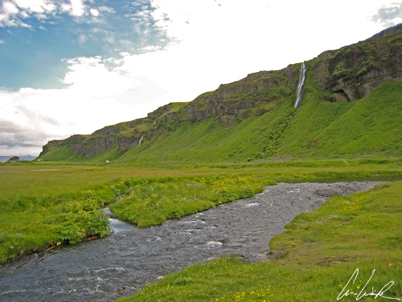
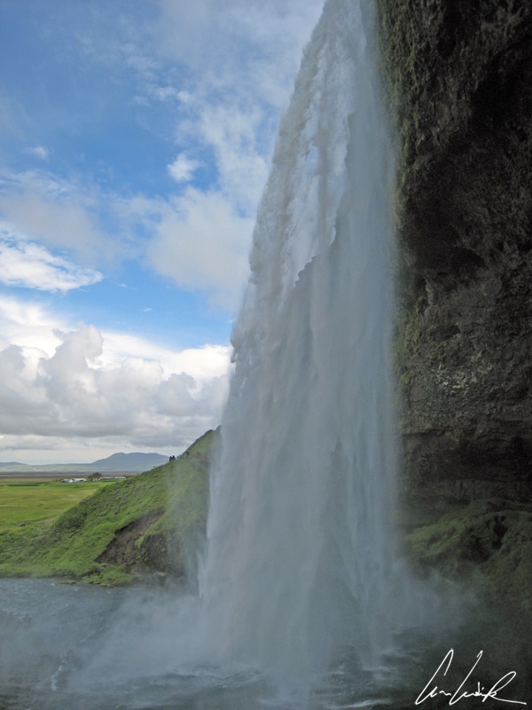
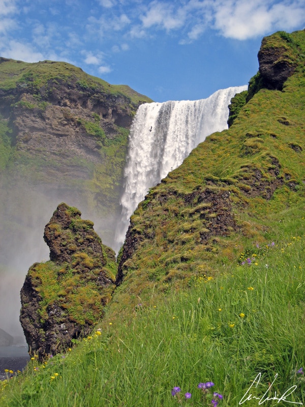
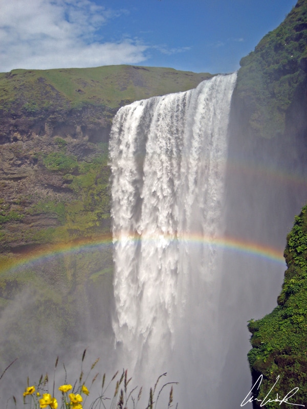
Water is omnipresent and is an essential element of Icelandic landscapes. Fresh or salty, hot or cold, cloudy or crystalline, water is present in all its aspects and forms! The thunder and clouds of mist generated by countless waterfalls are seen and heard from a distance… Near Þórsmörk, Mount Eyjarfjall ends abruptly in a steep cliff as the waterfall Seljalandsfross (“the fall of the pot milk “) drops 200 feet over the cliffs of the former coastline. Seljalandsfross is the best-known waterfall in Iceland, and the only fall behind which it is possible to walk without getting wet… depending on the vagaries of Njörd, a God among the Vanir in Norse mythology. A little further away, between the glaciers Eyjafjallajökull and Mýrdalsjökull, we first hear a distant murmur which turns very quickly into a thunderous roar as Skógafoss appears. Skógafoss fall is located on the Skoga river on the former coastline. It is the biggest fall in Iceland, a curtain of water with a width of 82 feet and a drop of 200 feet. The water spray produces a beautiful single or double rainbow visible on any sunny afternoon and becomes even more magical ! But be careful, do not disturb any supernatural creature – an elf, a troll (or two or a Troy !) or sylph – watching over the waterfall… “ Hlióðs bið ec allar kindir, meiri oc minni…” (I ask to keep quiet, the great and the humble…). Since the beginning of time, the Icelandic people coexist with the “huldufólk“, the hidden people: 55% of Icelanders are convinced of the existence of elves, trolls and goblins and 5% claim to have seen supernatural beings. On this small island where nature reigns supreme, all try not to disturb the hidden people. For instance, roads go around hills where elves are believed to live; a psychic would contact them to authorize the construction of houses. In Reykjavik, there is even a school, the Icelandic Elf School (Álfaskólinn) teaching Icelandic folklore, unique in the world, where you can earn a certificate in “study and research on the Elves and other invisible people.” From imagination to marketing, there is only one step…
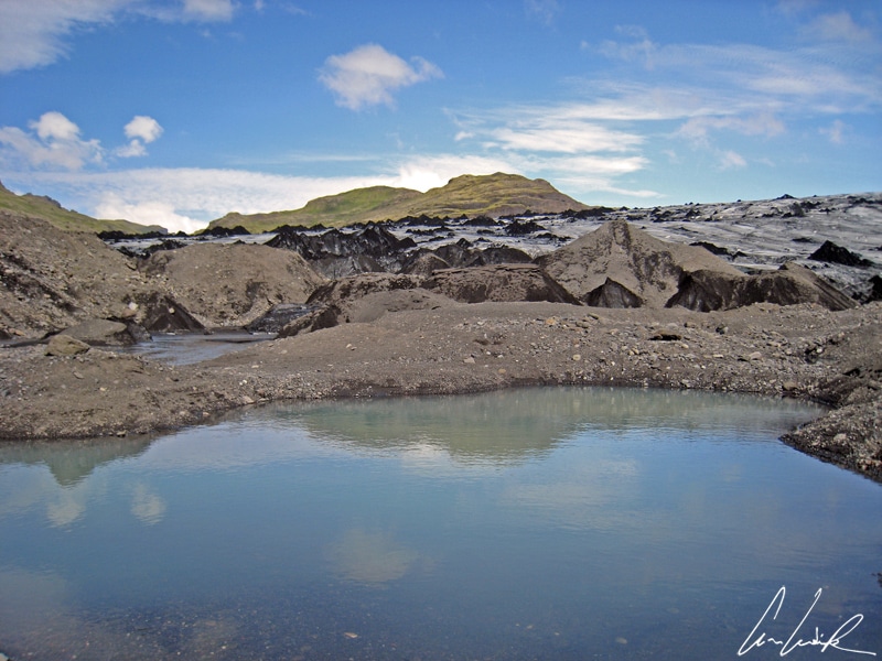
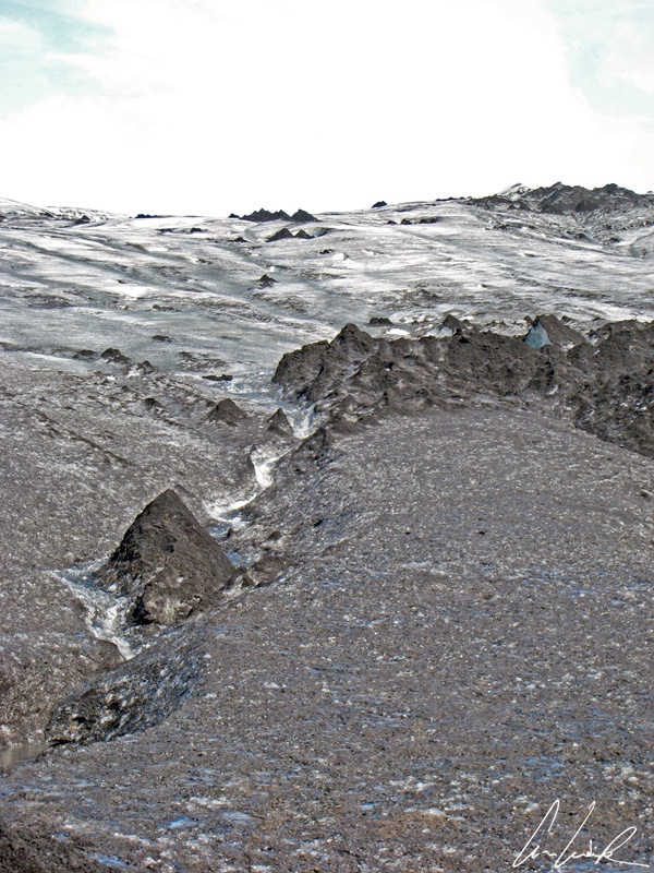
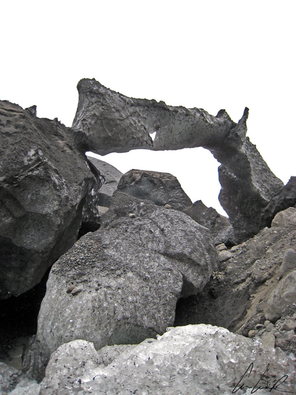
Solheimajokull Icefield
But let’s continue our story and break the ice between us! The frozen glacial tongue Sólheimajökull is in a region covered with fluorescent green moss and extends from the small icecap of Mýrdalsjökull on the South Coast. We feel dwarfed in this gigantic mass of ice that looks like an enraged ocean frozen forever. The 7-mile long Sólheimajökull, “the glacier that saw the sun” is streaked with black lines of ash deposited by the eruptions of nearby volcanoes. The glacier starts at an elevation of 3,608 feet and descends to 328 feet. It is crossed by numerous small streams which flow over or under the ice, shaping day after day this fantastic environment. It is a slow work of sculpture: the pressure of the snow and ice creates an amazing terrain of cracks, crevasses, sink holes, and ice ridges. Dripping water then smoothes the shapes and polishes the walls… Jean de La Fontaine’s line, “Patience and time do more than force and rage” takes on its full meaning here… And it is tough to remain unmoved by the beauty of a carved arch so patiently sculpted! Here the soil is mud. Distracted hikers may be surprised and return from their unique experience with black mud up to their calfs… you have been warned, be careful!
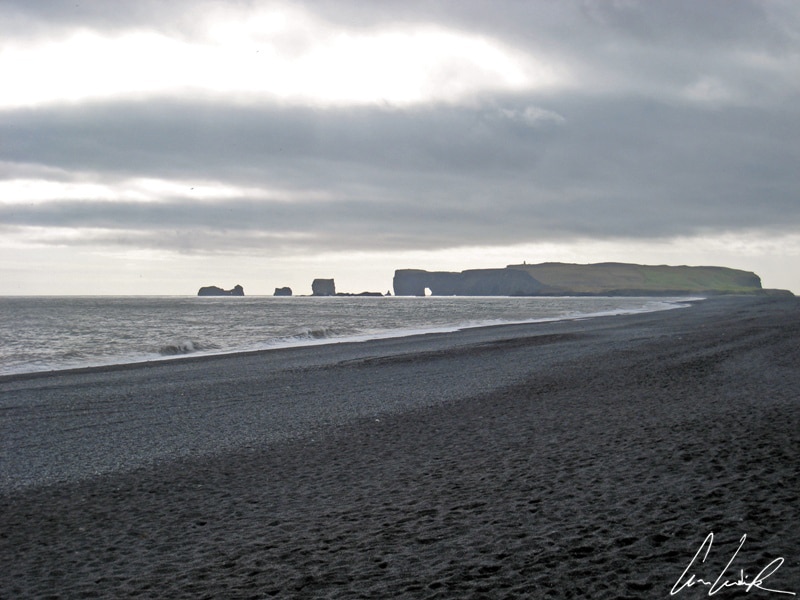
Black sand beaches of Reynisfjara
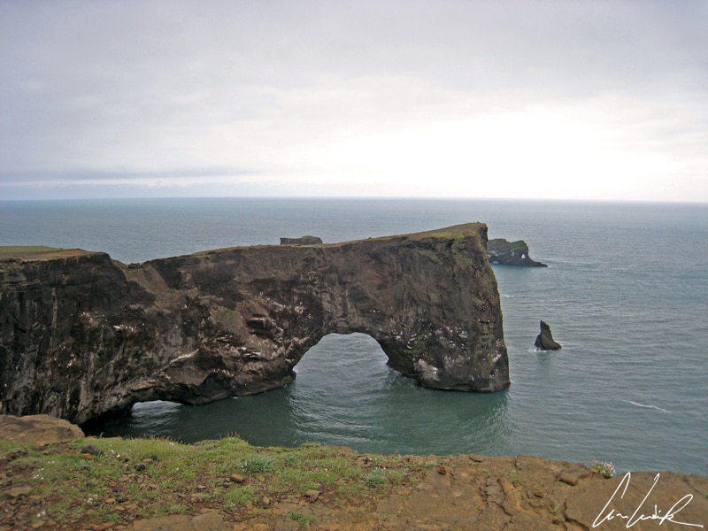
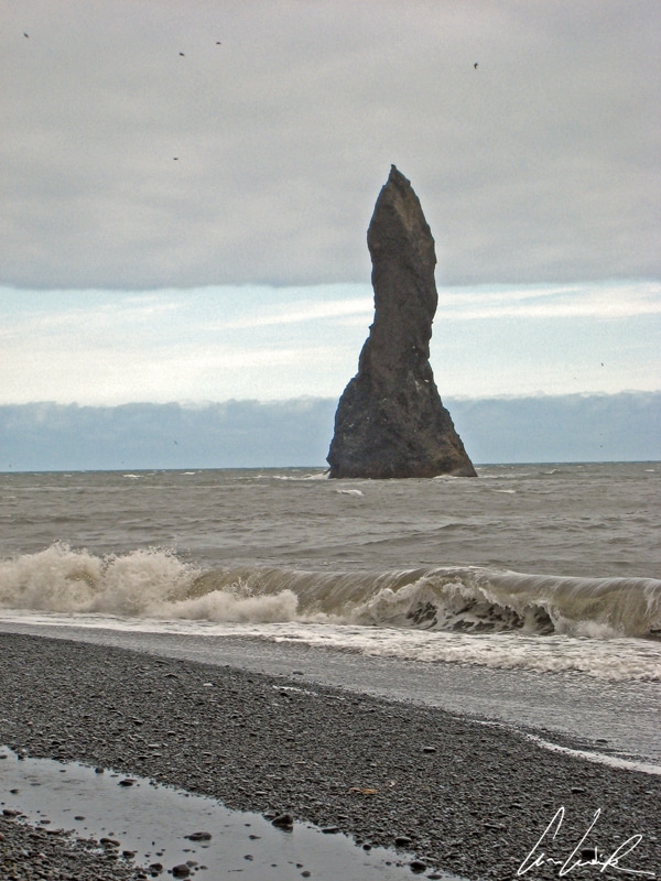
“Black is Black / I want my baby back / It’s gray, is gray / Since we went away, Ooh Ooh” by the rock band Los Bravos released in 1999… The south coast of Iceland is made up of beaches… black sand under gray skies. “Sandurs” is a generic term for an outwash deposit. The ocean waves, daughters of Aegir, the giant and the goddess who rules the sea in Norse mythology with his wife Ran and his nine girls, are often violent: they erode rocks and islands, flood the beaches of black sand and tirelessly shape the coastline. Near Vik, Cape Dyrhólaey is the southernmost point of Iceland. We observe a constant ballet of birds such as petrels, fulmars, or the famous puffins, an icon of the seabird world, stocky little clowns with a rolling gait… The puffin wears a sober outfit, predominantly black, a black plumage contrasting with a bright orange webbed feet and a huge bright orange-yellow striped bill almost as big as his head. It is this large beak, on which we want to give a little Quebec kiss, which earned the puffin the nickname of “clown of the sea” or “parrot“. Walking on the cliff, we also have a great view of the coast. On one side the infinite black sand beaches of Reynisfjara – on the other, a gigantic black arch of larva carved by the sea, a bay and the rocky lava columns of Reynisdrangar emerging from the sea. Dyrhólaey, where the cliffs are about 400 feet high, is a lighthouse built in 1927 to guide ships by bad weather… a few kilometers to the east lies the village of Vik or, by its full name, Vik i Myrdal, 110 miles Southeast of Reykjavik. It is the wettest place in Iceland (wear your yellow oilskin coat and your rain boots!)… Dominated by the Reynisfjall cliff, Vik Beach is ranked as one of the ten most beautiful beaches in the world… Of course, this classification is not based on water temperature (Brrr!. Wait until my tongue thaws!. Brrr!) but on beauty. The beach owes its reputation to its black basalt sand (Black is Black…) and to the presence of rocky pinnacles called Reynisdrangar (Troll’s rock). According to legend, two trolls were caught by the rising dawn and turned into stone while trying to lure a three-masted ship to the shore (Yep, crime does not pay !). For the more down to earth – who do not share this magic moment of magic in the land of fantasy and leprechauns – it is simply lava needles eroded by the wild sea and stormy wind serving as a refuge for numerous birds !
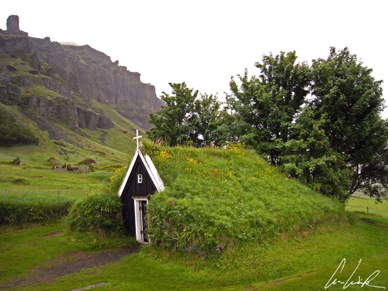
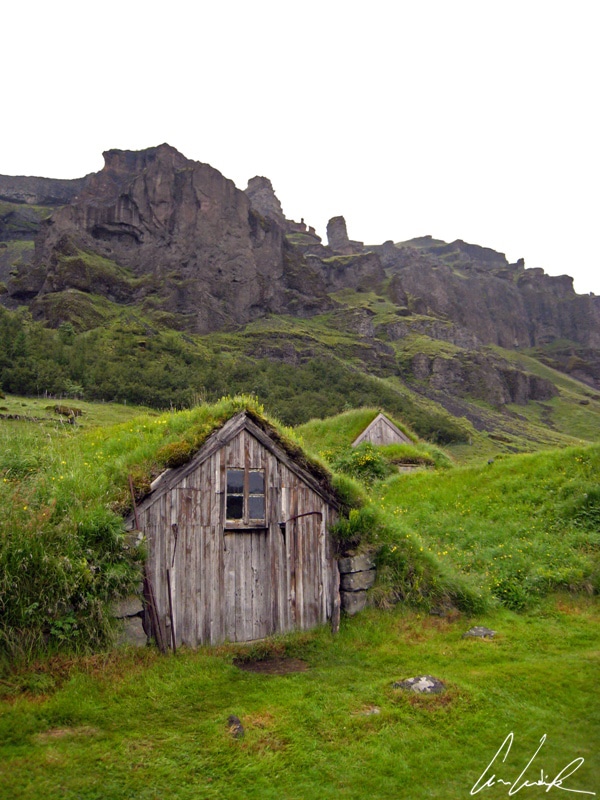
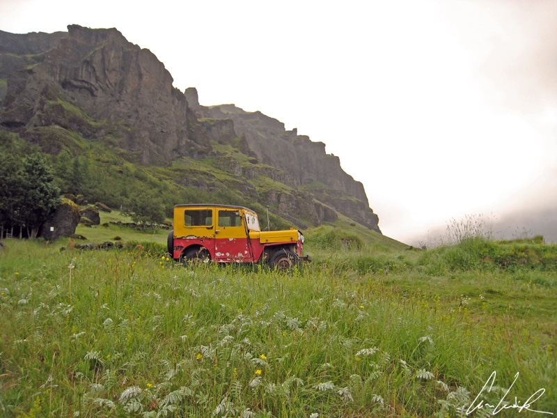
Nupsstadur
Back on road No. 1 lined with lupine flowers as far as you can see (which is a Defense Against the Dark Arts professor in Harry Potter) up to the village of Núpsstadúr. In this village, there was a “ferryman” in the early 20th century. Knowing the area well, he helped travelers to cross the Skeiðarársandur and the glacial rivers on horseback before bridges were built in 1974 to complete the Ring Road. The village has a collection of charming historical buildings with grass roof and is nestled at the foot of an impressive cliff and a small 17th-century church surrounded by poplars. Today, an old jeep covered with red and yellow rust sits nearby… This jeep, then all neat, was photographed for the first time in 1993. The vehicle was owned by two brothers, Philip and Eyjolfur Hannesson, who live in Núpsstadúr…
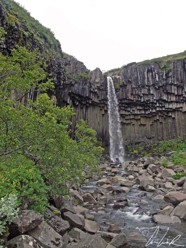
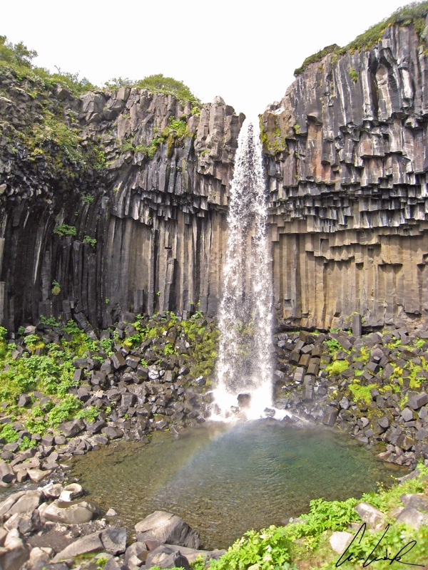
The nearby Skaftafell National Park is a promontory covered with vegetation at the foothills of the Vatnajökull. The Park was established in 1967 and became part of Vatnajökull National Park in 2008. It offers an unexpected oasis on the Southeast coast. However, do not expect to see big trees like those of our European forests. Here, it is just willows, birches, and poplars. Moreover, an Icelandic proverb says that if you get lost in an Icelandic forest, you only have to stand up! Do not tell me this joke leaves you cold ? In Skaftafell National Park, torrents rush down in cascades from Skaftafellsheiði, a wooded rocky promontory covered with flowers in summer. The Hundafoss Fall (“Dogs’ Fall”) was where riders once crossed the river to reach farms. It was named Dogs’s fall because during the swelling of the river dogs from nearby farms were sometimes carried away by the current into the abyss. But the park’s star is undoubtedly the Svartifoss waterfall. A breathtaking waterfall that flows over a cliff of about 65 feet down into a small bowl of green surrounded by black basalt column formations that give it its name, Black Fall. The columns are very regular, and their color varies from brown to deep black… utterly captivating even without fairy dust!
Við sjáumst !
Discover my others articles about Iceland


Visiting Iceland for the first time in February, and each post or picture I see just gets me that much more excited. Different season, but visiting many places you’ve discussed, so I’m loving the in-depth details of some spots!
I would love to visit Iceland on winter time to try to capture images of the mystical and stunningly beautiful aurora borealis as it dances over an Icelandic volcano or glacier !
So magical, historical, and beautiful! I’m such a big fan of Viking and Scandinavian folklore. Iceland is on my bucket list. The puffins look so cute too! And “hidden folk” – sounds like the Icelanders knew how to keep themselves entertained in winter.
Iceland, a country rich with roaring volcanoes, monolithic glaciers, icy mountains and deep fjords, has become a mecca for people looking to capture the raw, mystical power of its natural beauty. Its small population also means that the majority of its natural wonder remains nearly or completely untouched, giving people the opportunity to discover a world that seems empty and almost alien in nature !
Wow, what a beautifully descriptive piece! You paint such a vivid picture of this incredible island nation. Makes me want to go- right now! And I would be so up for troll & elf hunting too 🙂 Thanks for sharing this great post!
There is no place more mystical than Iceland. This mysterious land covered by glacial floodplains, waterfalls, towering mountains, fjords and even deserts of volcanic ash provides many stunning opportunities for the travelers!
I want to go to Iceland so bad!
Iceland is certainly a once in a lifetime experience that everyone should make plans for. It will leave you with vivid memories to last a lifetime.
Your photos are so lovely! Iceland has been on my bucket list for a while now. How cute is that little Nupsstadur church with the grass overgrowing it too! Thanks for sharing 🙂
Thank you 🙂 The country may be small but it is very rich in nature and culture and filled with contrasts. You discover a black sandy beach and crashing waves on peculiar rock formations… Next to it are green fields dotted with colourful flowers – and to top it off, a shimmering white glacier as a backdrop. Iceland is really a lifetime experience !
Iceland is now officially on my bucketlist. I would love to go there one day. Thank you for this beautifully written post and all the information. I will definitely keep your post in mind for when I’ll go there.
Most people come to Iceland to admire the nature – and it’s no wonder why ! There are picturesque glaciers, rivers and waterfalls just a stone throw away from colourful beaches, lush valleys and deserts. Even volcanoes underneath glaciers and hot springs surrounded by ice 😉
I visited Iceland last summer for 2 weeks. It was good to read your post and think back to our trip. First time I saw puffins in my life! They are so cute! 🙂
I’m sure you enjoyed you 2 weeks trip. There is an abundance of things to see and do in Iceland ! The puffin has become one of Iceland’s main attractions but it is so cute ! This is really a strange looking bird with a black back, white underparts, and a distinctive colorful beak 🙂
I would love to visit Iceland because of its wild nature and this post only wants to make me go more. Beautiful pictures and I loved reading about all those waterfalls.
For such a small nation, Iceland is absolutely packed with beauty and diversity. Vast, dramatic landscapes stretch out for miles, sprinkled with a handful of old farmhouses and fishing villages. You should see it by yourself at least once !
Nice pictures! I hope to walk along those black sandy beaches one day!
Reynisfjara beach is quite unique in Iceland, because it is stuck between 2 promontory (East and West), the sea to the South and a lagoon to the North. Quite a scenic combination ! And walking on the sand towards the mountain… it is an amazing moment.
OMG! I’ve never been to Iceland (it’s on my bucket list) but I’m already in love not only with its nature but also with its people and their believes… How cool is to still believe in trolls and elves?! Thanks for the amazing story.
Oh, and your photos are awesome! How gorgeous are the puffins??
Iceland is a fascinating country that is still continuously being reshaped through the geo-seismic activity. The country’s history and geography created the perfect setting for magical creatures, whose perceived existence sparks environmental protests to this day. Puffin is the most popular bird in Iceland. You can find millions of puffins in Iceland dotted around the coastline. So, come take a look for yourself !
Lovely post! Such amazing photos of a place I am dying to visit! I love Black Sand beaches and places that have volcanic activity, what a great experience you had! Makes me want to book a ticket to Iceland right now.
Iceland creates an environment of ever-changing landscapes: rough, wild, of incredible beauty and at times unpredictable. For any photographer interested in capturing images of stunning natural landscapes filled with raw power, Iceland is an absolute must-see 🙂
Iceland looks so beautiful! I have an overnight layover there this summer, so I’ll get a small taste of it, but I know I will want to be back soon for a proper visit.
Iceland is a once in a lifetime experience that everyone should make plans for ! Not only is this country the perfect playground for photographers, but it will leave you with vivid memories to last a lifetime 🙂
Iceland is so special country. Your post brings me back memories visiting this country quite a long time ago. The fact that Vik Beach is ranked as one of the ten most beautiful beaches in the world sounds interesting. Thanks for sharing!
I fully agree with you: Iceland is one of the most beautiful country I’ve ever visited. This mysterious land covered by icy glaciers & fiery volcanoes is amazing. The ruggedness of and stark contrasts present in Iceland’s landscapes makes them irresistible to travelers !
I love your writing. Iceland has that other worldy quality where one could imagine trolls and elves there. Gorgeous pics. I was there in winter. It’s like a different country each season, I’ve been told!
Ah, ah, Iceland has four seasons, although sometimes it doesn’t feel that way as the weather changes all the time. You’ll probably hear the joke “if you don’t like the weather, wait 5 minutes” when you’re in Iceland. No matter what time of year you choose to visit Iceland, it will be an amazing time anyway 😉
This is beautiful! I love all of the geysers. Iceland is so breathtaking and I cannot wait to visit it one day.
The mystical vapors of the earth funneling out of the ground and rising into the darkened air… Lets your mind and imagination wonder where on earth you are going !
Iceland ranks high on my bucket list! Thank you for creating such an informative article. I love how you included some curiosities along the text.
Thank you 🙂 Searching for elves and hidden people… the belief in elves, dead spirits and other supernatural phenomena are an inherent part of Icelandic culture ! There is no place more mystical than Iceland. Come take a look for yourself and let me know if you agree that there is no place quite like it… The mystical land of fire and ice !
Iceland seems like a place to be. The photos at the end of the article are breath-taking!!
Thank you 🙂 Iceland is known for its otherworldly beauty, a landscape that includes extreme contrasts, all in one melting pot. It’s true that Iceland is a photographer’s dream destination 🙂
We visited Iceland last year for a special occasion and it was truly one of the most magical countries we have been too. Your post is beautifully written and your photography is gorgeous. If I had been already you would definitely have convinced me to visit.
Thank you 🙂 Island was a wonderful experience ! It is a beautiful and fascinating island that makes for a wonderful holiday round and it’s a photographers paradise 🙂